Inconsistent swell for the weekend, cleanest Sunday
Western Australia Surf Forecast by Craig Brokensha (issued Wednesday 28th December)
Sign up to Swellnet’s newsletter and receive the West Australian Forecaster Notes and latest news sent directly to your inbox. Upon signup you'll also enter the draw to win a surf trip to P-Pass for you and a mate. It doesn’t get much easier so click HERE to sign up now.
Best Days: Keen surfers in the South West tomorrow morning, Saturday protected spots, Sunday morning, Monday morning
Recap
Poor conditions yesterday with a mix of onshore messy windswell and building groundswell. Protected locations offered an OK wave across the South West into the afternoon and evening.
This morning the mix of swells was coming in at 2-3ft around Perth and Mandurah with workable winds, while the South West remained poor with a S/SW breeze.
This week and weekend (Dec 29 – Dec 1)
Even though the swell will continue to ease into tomorrow, conditions were expected to be much cleaner across the region, but the South West is now only due to see S/SE winds, more SE around Perth.
The swell will be easing from 3-5ft in the South West and 1-1.5ft to the north, even smaller early Friday morning with S/SE winds again.
An onshore change is due mid-late morning across all coasts and this will spoil a new strong and inconsistent W/SW groundswell that will be filling in.
The low responsible for the swell fired up over the weekend and has been moving slowly east through our far swell window south-east of Madagascar.
The swell should build slowly Friday, reaching 5-6ft+ across the South West by dark, holding a similar size Saturday. Perth is only due to see infrequent 1-2ft sets.
Fresh S/SE winds will favour protected spots on Saturday (more SE around Perth during the morning).
Sunday looks cleaner with an E/SE breeze as the swell eases off from 4-5ft in the South West and 1-1.5ft in Perth.
Next week onwards (Dec 2 onwards)
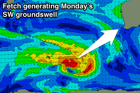
 Some small SW groundswell is due to fill in Monday across mainly the South West, generated by a weak fetch of strong to gale-force W/NW winds through the southern Indian Ocean over the coming days.
This will then be followed by a weaker fetch of trailing but slow moving W/SW winds, producing a smaller background swell for Wednesday.
Monday's pulse should build to 3-5ft across the South West, and only 1ft in Perth, easing from 3-4ft+ Tuesday and 3-4ft Wednesday morning.
Conditions at this stage will be best Monday morning with an E/SE offshore ahead of a see breezes, and then S/SE winds Tuesday and Wednesday.
Another small SW swell is due late week, but more on this Friday.

