Large powerful groundswell for the weekend
Western Australia Surf Forecast by Craig Brokensha (issued Friday 23rd December)
It's only two sleeps to go until Christmas Day. If you're looking for a surfer's perfect present and don't want to endure the shopping centre masses you can pick up a Swellnet Pro Subscription gift pack. Treat someone else or treat yourself and get a free Swellnet leggy and surf tested sunscreen: https://www.swellnet.com/pro/gift
Best Days: Protected spots later Saturday and Sunday, exposed breaks Monday morning, Wednesday morning protected spots, exposed breaks Thursday
Recap
Poor onshore surf across all coasts yesterday with a kick in local windswell.
Today was cleaner and better with a building W/SW swell coming in at 3-5ft in the South West, with 1-2ft sets around Perth (1-1.5ft Mandurah).
This weekend and next week (Dec 24 - 30)
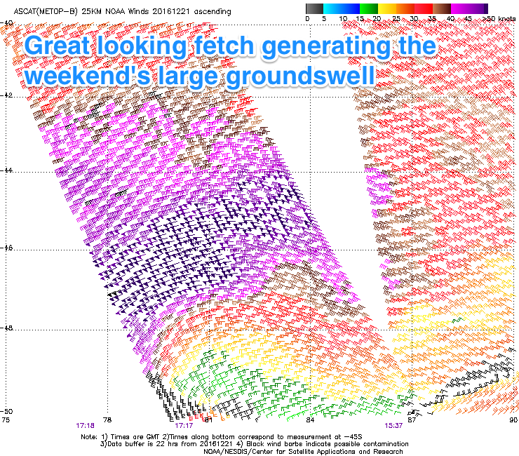
 We've got some great satellite observations of the intense low currently south-west of us, with a fetch of severe-gale to storm-force (up to 55kt) winds being aimed through our swell window.
The low is currently slowly weakening while stalling nicely to our south-west, helping to draw out the longevity of the swell.
Early tomorrow morning we're due to see 3-5ft of W/SW swell from this afternoon, with the groundswell proper arriving late morning in the South West and building to 8-10ft by dark, with Perth pulsing to 2ft+.
A peak is due overnight with easing 6-8ft surf Sunday morning (possibly the odd bigger bomb at dawn) and 2ft+ in Perth.
Winds for most of the weekend look to be fresh from the S/SE, stronger Sunday leaving protected locations with the best conditions.
Monday looks better for exposed breaks with an E'ly offshore ahead of a W'ly change during the middle of the day/early afternoon.
The South West should be easing from 5-6ft or so and 1-2ft in Perth.
The onshore change through Monday will be linked to another mid-latitude low moving in from the south-west.
This system has been upgraded a little from Wednesday, with a good fetch of W/SW gales due to be generated through our swell window from Saturday evening through Monday afternoon.
A large SW groundswell is due from this low, building Tuesday afternoon, reaching 6-8ft+ across the South West by dark and 2-3ft in Perth although with S/SW winds.
Protected spots should be OK as the swell eases Wednesday with a fresh S/SE breeze.
Longer term a long-range and long-lived W/SW groundswell is due from Friday through next weekend, produced by a slow moving and distant polar low in the southern Indian Ocean. More on this Monday though.
Have a Merry Christmas and great weekend!


Comments
Already starting to kick in Margs.
Jeez I picked the wrong time to head east! Ha ha. Blue bottles and small waves for now. Thanks Swellnet for a great year of forecasting, merry Xmas!
You too Nick!
Wasn't looking too shabby for the early session this morning.
A little rogue-ish across the Margs stretch though.
Up here it was almost perfect.
Today is even bigger but a bit raw and strong winds.
That was good few nice bazzas there.
Thanks. Merry Christmas everyone.