Average end to the week, better early next week
Western Australia Surf Forecast by Craig Brokensha (issued Wednesday 14th December)
Sign up to Swellnet’s newsletter and receive the West Australian Forecaster Notes and latest news sent directly to your inbox. Upon signup you'll also enter the draw to win a surf trip to P-Pass for you and a mate. It doesn’t get much easier so click HERE to sign up now.
Best Days: Swell magnets dawn tomorrow around Margs, Saturday morning Margs, Tuesday morning both regions, Wednesday morning Margs
Recap
A slight kick in swell yesterday to 3-5ft in the South West and 1-1.5ft to the north but conditions were average with fresh to strong S-S/SE winds.
Today the surf cleaned right up but there wasn't much size left on the coast.
This week and weekend (Dec 15 - 18)
The surf will become even smaller tomorrow, with inconsistent 2-3ft sets left across magnets in the South West, tiny elsewhere.
We're looking at E/NE winds at dawn in the South West, tending onshore by mid-morning and then back to the SE-S/SE Friday but with strength.
With even smaller surf Friday conditions will be poor and not worth chasing.
A small increase in mid-period and average SW swell is due Saturday, from a weak fetch of polar W/SW winds today and tomorrow.
Not major size is expected with 3-4ft sets due but conditions are looking better with an E'ly offshore ahead of sea breezes. Perth will be very tiny.
Sunday is another lay day with a fresh S/SW change and easing surf.
Next week onwards (Dec 17 onwards)
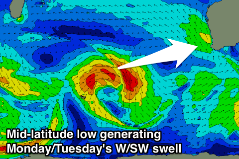
 The mid-latitude low talked about last update us still on the cards, with it expected to form south-east of Madagascar this afternoon and produce a fetch of W/SW gales while tracking east over the coming days weakening south-west of us Saturday evening.
A good W/SW groundswell is due off this low, building Monday to 5-6ft later in the day Monday (1-2ft Perth), easing from 4-6ft Tuesday morning. The swell will be least consistent Monday and more consistent Tuesday due to the later part of the swell being generated closer towards us.
Monday will see S/SE winds as a high pressure ridge moves in from the west, while Tuesday morning is the pick with E/SE offshores ahead of sea breezes.
Longer term there's some similar sized swell due later week but with what looks to be onshore winds. More on this Friday.

