Pumping end to the week
Western Australia Surf Forecast by Craig Brokensha (issued Wednesday 7th December)
Best Days: Thursday, Friday morning, Saturday morning swell magnets in the South West, semi-protected spots Sunday morning
Recap
Poor surf yesterday and this morning, but we should see some size developing through the day from the front linked to today's change.
This week (Dec 3 - 9)
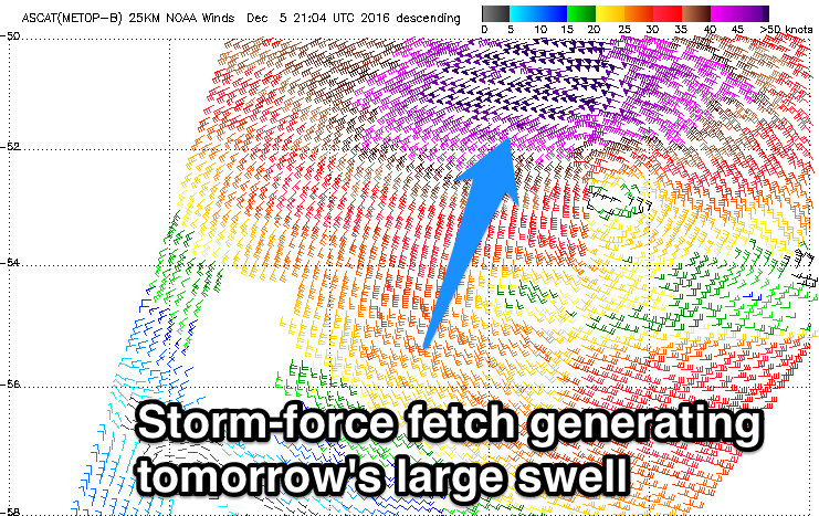
 Today's front spawned off a vigorous polar low, with satellite observations confirming a fetch of severe-gale to storm-force W/SW winds being aimed through our south-western swell window. During yesterday the low weakened while tracking towards us, setting in motion a large and powerful SW groundswell.
This groundswell is due to fill in overnight, peaking tomorrow morning to a large 10-12ft across the exposed reefs in the South West and 2-3ft in Perth.
Conditions are looking excellent with a E/SE offshore across most locations (E'ly Perth) give into mid-late afternoon sea breezes as the swell eases.
Friday is due to be much smaller with easing 4-5ft sets in the South West and 1-2ft waves in Perth with a morning E/SE offshore.
Saturday isn't looking that flash with small surf and a morning E/SE offshore, but a new inconsistent W/SW groundswell is due Sunday.
This swell, discussed on Monday is being generated by a distant polar frontal progression that will move closer towards us over the coming days while weakening.
Margs should see 4-6ft sets as it peaks through Sunday with 1-1.5ft waves in Perth and the odd 2ft bomb likely. Winds are OK but not great and likely from the S/SE.
Next weekend onwards (Dec 12 onwards)
Into early next week onshore winds are likely to kick in with small to moderate amounts of swell, slightly cleaner but easing from Wednesday.
Therefore make the most of the coming days waves.


Comments
Coupla!