Strong S/SW swell tomorrow, smaller cleaner from Wed, XL swell developing Sun
Western Australia Surf Forecast by Craig Brokensha (issued Monday 25th July)
Best Days: Perth tomorrow, everywhere Wednesday and Thursday
Recap
Easing surf from Friday with onshore winds across the South West and cleaner but lumpy 2ft waves around Perth.
Into Sunday a new S/SW groundswell filled in offering 6-8ft sets in the South West, smaller to 1-2ft through the morning across Perth before building through the day. Variable winds created workable conditions across the South West, swinging onshore into the afternoon with Perth also being clean through the morning.
Today the S/SW groundswell was on the ease with average S'ly winds across the South West and cleaner conditions to the north.
This week and weekend (Jul 26 - 31)
Unfortunately like today, tomorrow will remain average in the South West as the frontal activity pushing up towards the country just gets close enough to influence our local winds.
A moderate SW'ly is due, easing through the day and this will spoil a strong new pulse of long-period S/SW groundswell.
This swell was generated over the weekend by a polar fetch of storm-force W/SW winds moving east-northeast through our swell window.
Exposed breaks in the South West should see 8ft+ sets at the swells peak tomorrow morning, with 2ft to possibly 3ft sets around Perth.
Winds will be offshore to the north, tending variable into the afternoon.
Wednesday is the day to surf the South West with an offshore E/NE tending light N/NE breeze with easing 5-6ft sets, Perth should drop from 1-2ft.
Into Thursday some reinforcing SW groundswell is due across the South West from a fetch of not overly strong W/NW winds through our south-western swell window.
Margs should hang around 4-5ft+ with 1-1.5ft sets possible around Perth. Offshore E/NE tending variable winds are due again, creating nice clean conditions.
A new pulse of moderate to large SW groundswell is due on Friday, produced by a better fetch of post-frontal and polar W/SW gales in the Heard Island region over the coming days.
This swell should come in around an inconsistent 6ft to occasionally 8ft in the South West and 2ft up around Perth.
 If you're looking to surf you'll have to get in early as a variable breeze will give into a strengthening NW'ly.
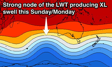
Now, as talked about last week, a strong cold-outbreak is due across the south-east Indian Ocean owing to an amplifying node of the Long Wave Trough.
This will direct a series of very strong and powerful polar fronts up and towards us, the first projecting a fetch of gale to severe-gale SW to W/SW winds up into us through the middle to end of the week, pushing across us Friday evening.
A stronger and broader front will piggy-back over the top of this system, generating a fetch of severe-gale to storm-force W/SW winds on top of an already active sea state, moving in over the weekend.
What will result is a mid-period increase in W/SW groundswell through Saturday from the front pushing across us Friday evening, with the groundswell filling in through Sunday morning, ahead of the largest kick later in the day and Monday morning.
Unfortunately strengthening onshore W/NW winds are due Saturday, becoming gale-force from the W/NW tending W/SW Sunday. Winds should improve through Monday but still be fresh from the S/SW tending S'ly.
Size wise we're probably looking at a peak to 3-5ft across Perth with stormy XL 15-18ft+ waves around Margs. We'll have a closer look at this Wednesday though.


Comments
Is SN still doing the indo forcasts? Or is this in the SN pro?
Thanks .
Yeah notes are here: https://www.swellnet.com/reports/indonesia/bali/uluwatu/forecaster-notes
Will have an update tomorrow.