Plenty of swell but average conditions until Sunday
Western Australia Surf Forecast by Craig Brokensha (issued Wednesday 20th July)
Best Days: Later Friday, Saturday morning Perth, both coasts Sunday through Wednesday
Recap
Yesterday was excellent across most coasts through the morning with the W/SW groundswell coming in strong to 6ft+ across the South West, 3-4ft in Mandurah and 3ft up around Perth. Onshores developed across the South West into the afternoon with more variable breezes to the north.
Today the surf was a bit smaller with onshores across the South West, N'ly winds in Mandruah and lighter offshores around Perth which are now increasing from the N'th. A new SW groundswell is due to build this afternoon across all coasts with sets reaching 6-8ft in the South West and 2ft+ up around Perth although with winds deteriorating further.
This week and weekend (Jul 21 - 24)
This afternoon's expected increase in SW groundswell should ease back into tomorrow morning from a similar size (6-8ft and 2ft+ respectively) but winds will continue to be an issue with onshore S/SW tending W'ly winds across all coasts.
This will be linked to a strong polar front pushing up and into the south-west of the state, producing a large S/SW groundswell pulse for Friday.
A fetch of S/SW gales pushing right up and into us should produce large 8-10ft sets through the middle of the day/ afternoon across the South West with Perth building to 2-3ft into the afternoon. Onshore S/SW winds will persist through the morning, but lighter S'ly breezes are due to develop into the afternoon across the South West, with SE winds a possibility around Perth (likely more variable).
The swell will ease into Saturday and unfortunately another approaching front will swing winds back onshore from the W/SW tending S/SW across the South West. Perth should be cleaner with an early offshore and easing 2ft+ waves.
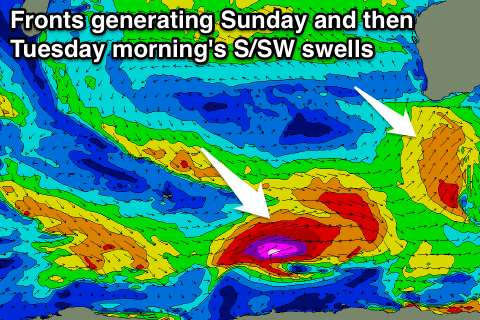
 This secondary polar front won't be as strong and will form later in our swell window, with a smaller S/SW groundswell due into Sunday.
The South West is likely to see smaller 6ft+ waves across magnets, with 2ft waves in Perth, easing back into Monday.
Winds are looking better though with an offshore E/NE'ly early across all coasts, tending variable into the afternoon.
Next week onwards (Jul 25 onwards)
Offshore winds should continue through Monday as Sunday's swell eases back a touch ahead of a late increase in new long-period S/SW groundswell.
A much stronger and better aligned polar front firing up along the polar shelf, then projecting north-east towards the Bight will produce a better fetch of severe-gale to storm-force SW winds through our swell window.
This swell should peak Tuesday morning to a stronger 8ft across the South West on the sets and 2ft+ in Perth, easing back through the day under offshore E/NE tending variable winds, smaller into Wednesday morning.
Longer term there's plenty more pulses of long-period S/SW groundswell energy from back to back polar lows developing late in our swell window. More on this Friday.

