Plenty of swell but onshore to the south, better over the weekend
Western Australia Surf Forecast by Craig Brokensha (issued Monday 27th June)
Best Days: Perth Thursday and Friday (early South West Friday), South West Saturday and both coasts Sunday
Recap
An average weekend across the South West with leftover onshore waves Saturday and then a very large SW groundswell Sunday but with W/NW devil winds. Perth and Mandurah were much better Sunday with 3ft sets and morning offshores.
Today the swell is smaller and back to the 6ft+ range with terrible NW winds in the South West and 2ft waves to the north under better winds early morning.
This week and weekend (Jun 28 – Jul 1)
The next two days aren't looking too flash with a new short-range W'ly swell due from a mid-latitude now not expected to form. Instead we're looking at a weaker trough moving across us and also easing surf tomorrow, further into Wednesday.
Onshore winds from the NW tending W'ly will write-off Margs tomorrow, with tiny waves and N'ly tending NW winds also leaving no options around Perth.
SW winds on Wednesday and no decent swell will see even poorer conditions across all locations.
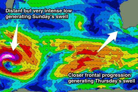
 A large SW groundswell is due into Thursday, with it currently being generated by a strong polar low that's formed in the Heard Island region. A fetch of gale to severe-gale W/SW winds will tend more SW and be projected towards us over the coming days before weakening.
A solid 6-8ft+ of SW groundswell is expected, peaking through Thursday and then easing from 5-6ft+ Friday morning. Perth should see 2ft waves through Thursday, easing from a similar size Friday.
Winds are due to remain onshore from the W Thursday in the South West, with better E'ly tending variable winds around Perth. Friday may see an early NE'ly across the South West, but we'll review this Wednesday.
This weekend onwards (Jul 2 onwards)
Thursday's swell will continue to ease through Saturday with tiny waves around Perth and 3-5ft sets in the South West as better E/NE offshores kick in around Margs.
Sunday is the better of the two days, with a new long-period and inconsistent SW groundswell due across the state. This will be generated by a really strong but distant polar low developing south-east of South Africa tomorrow. A fetch of severe-gale to storm-force W'ly winds will be projected east-southeast through our western swell window before weakening once passing Heard Island.
Strong but inconsistent 5-6ft waves are due across Margs, with 8ft sets, while Perth should offer 2ft sets. Winds are looking good but gusty offshore from the E/NE all day.
Into next week average waves are due ahead of an active period of onshore storm swell from Wednesday. We'll have another look at this next update though.

