Average weekend, better swells next week
Western Australia Surf Forecast by Craig Brokensha (issued Friday 17th June)
Best Days: Protected spots in the South West tomorrow morning, Tuesday morning South West, Thursday morning Perth
Recap
Good fun waves across most locations yesterday with a strong new SW groundswell offering 6ft sets in the South West with SE winds persisting all day. 1-2ft waves were seen to the north, holding a similar size into this morning.
Margs was also good today with a straight offshore wind and good clean sets around 5ft across the exposed reefs.
This weekend and next week (Jun 18 - 24)
It's not the best looking weekend with tomorrow morning being the only real chance for a decent wave, and that's in protected locations across the South West.
A fresh and gusty but easing NE tending N'ly wind is due. Exposed south facing breaks should still offer 4ft+ waves before easing through the day, smaller into Sunday. Perth and Mandurah will become tiny.
NW tending W'ly winds will create poor conditions Sunday as some new W'ly swell fills in from a stalling mid-latitude low in the southern Indian Ocean this week.
The South West is expected to build to 4ft or so Sunday afternoon with 2ft sets around Perth, easing back Monday.
Winds will remain onshore during the morning from the SW, but swing S/SE through the day. This will be as a new small SW groundswell fills in, reinforced by a slightly better pulse Tuesday.
These swells will be generated by back to back weak polar frontal systems, with the second system being stronger than the first. Size wise Tuesday should see good fun 3-5ft sets in the South West, maybe 1ft Perth with offshore E/SE tending SW winds.
Of greater importance is the developments into early and later next week.
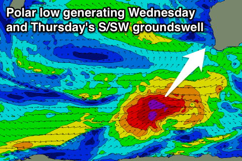
 Firstly a vigorous polar low is expected to fire up in the Heard Island region Sunday afternoon, projecting a fetch of gale to severe-gale W/SW winds north-east towards us.
A moderate to large long-period S/SW groundswell should result, building strongly Wednesday, peaking overnight and easing Thursday.
Margs should build to the 6-8ft+ range later in the day and easing from 6-8ft Thursday morning. Perth should kick to 2ft late and ease from a similar size Thursday morning.
Unfortunately as the swell builds Wednesday onshore W/SW tending S/SW winds are due, persisting from the S/SW Thursday around Margs, better from the SE to the north.
An even stronger polar low is forecast to fire up in the southern Indian Ocean mid-late next week, but we'll have another look at this Monday. Have a great weekend!

