Great Friday, average weekend and improving again mid-next week
Western Australia Surf Forecast by Craig Brokensha (issued Wednesday 8th June)
Best Days:
Recap
Very large messy waves across the South West yesterday with Monday's large SW groundswell holding into the morning. Protected bays and points where the only option.
Mandurah saw 3-4ft surf but poor conditions with a S'ly breeze, with workable 3ft sets in Perth.
This morning the swell is a touch smaller but still average in the South West, while Mandurah and Perth offered OK conditions under S/SE winds.
This week and weekend (Jun 9 - 12)
Our large SW groundswell event will continue to ease into tomorrow but conditions will remain poor down South with a strengthening W/NW'ly ahead of a W/SW change. Perth will be clean and around 2ft before the W'ly kicks in mid-morning.
Our new SW groundswell for Friday is still on track with the polar low generating the swell to our south-west now easing.
This swell is expected to arrive around dawn in the South West and mid-late morning in Perth, peaking at 6ft+ and 2ft respectively.
Conditions are looking good all day with offshore E/SE tending more variable E/NE winds, so there's no rush to go early.
Saturday will be pretty average with the swell easing under strengthening N/NE winds, limiting options across the state.
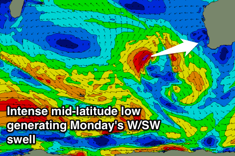
 Into Sunday afternoon and Monday morning, a new moderate to large sized short-range W'ly swell is due. This will be created by a mid-latitude front strengthening and turning into a cut-off low west of us at the end of this week.
A tight fetch of gale to severe-gale W/SW winds will be aimed through our western swell window, with the low weakening while moving across us Sunday.
Onshore W/NW winds are due as the low moves across us, with the swell kicking late and peaking Monday morning to 6-8ft in the South West and 2-3ft around Perth. Winds aren't the best though with a fresh S/SE'ly favouring protected breaks.
Next week onwards (Jun 13 onwards)
Some fun moderate sized SW groundswell is on the cards for Tuesday afternoon and Wednesday across the South West as a couple of unfavourably aligned but strong and back to back frontal systems move through our swell window east of Heard Island.
At this stage the swell looks to peak in the 6ft range across the South West and 1-2ft up in Perth with offshore winds Wednesday, but more on this in Friday's update.

