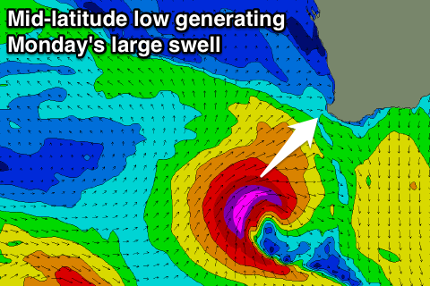
Good end to the week, large swells for next week but onshore
Western Australia Surf Forecast by Craig Brokensha (issued Wednesday 20th April)
Best Days: Thursday, Friday, Saturday morning protected breaks, Perth and Mandurah Monday
Recap
Yesterday some new swell started to show across the South West with 4ft waves under a better than expected SE breeze. Perth and Mandurah saw some peaky fun short-range swell to 1-2ft with similar winds.
The swell peaked into the afternoon/evening, but this morning we were still seeing 4-5ft waves across the South West with a morning SE breeze again, while Perth and Mandurah were back to 1-1.5ft.
This week and weekend (Apr 21 - 24)
Tomorrow, Friday and Saturday morning are looking fun across the South West, with a new SW swell for tomorrow to 4-5ft, ahead of a better long-period SW groundswell later in the day, peaking Friday morning to 5-6ft+. A peak in Perth is due Friday to 1-2ft.
These swells have been produced by persistent polar frontal activity to our south-west the last few days, and conditions are looking great.
A moderate E/SE offshore wind is due tomorrow, likely tending more SE into the afternoon, while Friday should see fresh E/NE winds, tending more NE through the day and then easing.
The swell will ease through Friday afternoon and down further Saturday but you'll have to hit up somewhere out of the NE wind, with this swinging more N'ly through the day.
Sunday will be a lay day with a fresh W/NW tending SW onshore breeze and mix of swells.
Next week onwards (Apr 25 onwards)
 As talked about last update, an intense and tricky mid-latitude low is forecast to fire up to our south-west Saturday, aiming a fetch of severe-gale to storm-force W/SW to SW winds into the south-west of the state.
This will produce a large consistent W/SW tending SW groundswell for Monday, coming in at a raw 8-10ft+ across the South West, with Perth due to kick to 2-3ft through the day.
Winds aren't looking the best with an onshore W'ly breeze across the South West, while Perth and Mandurah should see more favourable E/SE offshores ahead of sea breezes.
A polar front will then push up and into us on the backside of the mid-latitude low through Monday and Tuesday, producing a secondary large SW groundswell for later Tuesday and more so Wednesday but with gale-force W/NW tending SW winds, easing Wednesday. We'll have a closer look at this in Friday's update though.


Comments
Stacked lines at Margs this morning.