Average couple of days, good Friday and Saturday
Western Australia Surf Forecast by Craig Brokensha (issued Monday 11th April)
Best Days: Friday, Saturday
Recap
A good new S/SW groundswell filled in Saturday morning to 4-5ft+ across the South West but gusty SE winds made for tricky conditions.
The surf held around the same size Sunday to 4-5ft, and better but still gusty E/SE winds created clean but tricky conditions, easing off late morning creating better conditions into the afternoon.
Today the swell was a touch smaller and around 3-5ft as straight but strong offshores continued.
Perth and Mandurah have failed to offer any decent surf at all with the southerly direction of the swell and lack of major size.
This week (Apr 9 - 15)
Our current swell is due to ease off through tomorrow from an inconsistent 3ft to possibly 4ft across swell magnets, under less than favourable N/NE tending NW winds, creating average conditions.
A new pulse of SW groundswell is due Wednesday, from a vigorous but unfavourably aligned and south-east tracking pre-frontal fetch of gale to severe-gale W/NW winds.
An uptick to 3-4ft+ is due across the South West, with Perth and Mandurah remaining tiny, but conditions are looking a little average with a light to moderate onshore W/NW breeze.
Thursday morning is looking similarly average with a lingering SW'ly and low point in swell.
Into the afternoon though, our long-range and inconsistent W/SW groundswell is due to fill in, generated by a strong but distant polar frontal progression that developed south-east of South Africa late last week.
The swell from this system will be really inconsistent but should build through the afternoon and reach 3-5ft later in the day, peaking Friday morning to 4-6ft. Perth should kick to 1-1.5ft later Thursday and peak Friday to 1ft to occasionally 2ft.
Winds are looking better Friday morning as a ridge of high pressure moves in from the west creating much better and improving conditions with an early SE tending E/SE breeze (holding all day).
This weekend onwards (Apr 15 onwards)
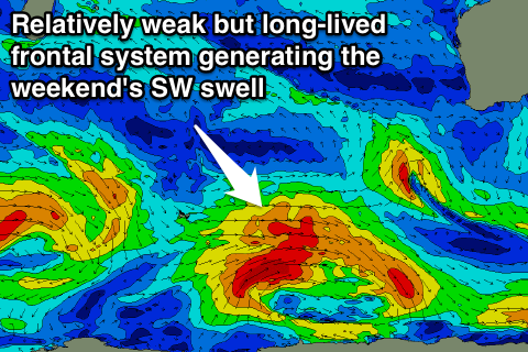
 Another more consistent and similar sized SW groundswell is due to fill in through later Saturday afternoon, generated by a relatively weak but pro-longed polar low aiming a fetch of W/SW gales through our south-western swell from its development south-west of Heard Island this evening, right through until its south-west of us into the end of the week.
Saturday morning is likely to be in the 3-5ft range, with a kick into the afternoon to 4-6ft later in the day, easing from a similar size Sunday morning.
Conditions should continue to be good Saturday with offshore E/NE breezes, tending more NE and then variable into the afternoon ahead of a shallow S/SW change Sunday. So make the most of Saturday!
Longer term we may see some better swell activity into later next week, but more on this Wednesday.

