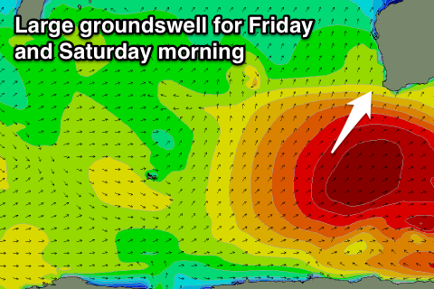
Large and clean Saturday morning
Western Australia Surf Forecast by Craig Brokensha (issued Wednesday 30th March)
Best Days: Friday afternoon/evening in the South West, Saturday, Sunday morning, Monday morning
Recap
Small waves across the South West with average winds early each morning, improving while tending more offshore through the day. Tiny offerings to the north.
This week and weekend (Mar 31 – Apr 3)
We'll finally see our mini swell drought broken through tomorrow, but more so into Friday and Saturday.
A strong polar low forming late in our southern swell window has generated a good pulse of S/SW groundswell for tomorrow that should peak during the day to 4-6ft across exposed reefs in the South West. No decent size is due around Perth due the S'ly nature of the swell.
Unfortunately an early variable wind now looks to be light to moderate onshore from first light, freshening through the day, creating average conditions.
Moving onto Friday and Saturday's developments, and a strong node of the Long Wave Trough is currently to our south-west, with it due to move east over the coming days.
 The Long Wave Trough steers and strengthens polar fronts up and just to the west of where it is positioned, and with it slowly moving east, we'll see back to back frontal systems steered initially up through our south-western swell window and then southern swell window as the activity shifts further east.
An initial cold front projecting north-east this evening and tomorrow should produce a fetch of gale to severe-gale SW winds, followed by a secondary intensification more through our southern swell window Friday.
Two pulses of SW and S/SW groundswell are expected, building strongly through Friday and peaking during the day to a good 6-8ft across the South West, with 10ft bombs sets, and building to 2ft around Perth.
The swell should then ease out of the S/SW through Saturday from 6-8ft+ early around Margs and 2ft up in Perth, further down from 4-6ft Sunday and 1ft+ in Perth.
Now, conditions Friday morning will be average, but protected spots will be good into the afternoon across the South West with a fresh SW tending S'ly breeze and then S/SE late.
Saturday looks excellent as a ridge of high pressure moves in, swinging winds light offshore from the E ahead of afternoon sea breezes.
Sunday then looks a little funky with less than ideal S/SE tending S/SW winds, so make the most of Saturday!
Next week onwards (Apr 4 onwards)
The weekend's swell will continue to ease back through early next week with morning SE winds Monday, and less favourable onshore winds Tuesday.
A small mid-latitude low firing up south-west of us during early next week could produce a moderate sized short-range SW swell for Wednesday next week but with average winds. We'll have a closer look at this Friday though.


Comments
Not sold on that swell direction will have to see on the day gonna be fun but