Small and clean ahead of some good swell from Thursday
Western Australia Surf Forecast by Craig Brokensha (issued Monday 28th March)
Best Days: Thursday morning, later Friday in the South West, Saturday, Sunday, Monday
Recap
Tiny clean offerings in Perth and Mandurah, while the South West was the pick for waves over the weekend with clean conditions and sets in the 3-4ft range. Today the swell has started to ease from 3ft with good clean conditions.
This week and weekend (Mar 29 – Apr 3)
The swell will really bottom out into Tuesday and Wednesday with small 2ft to maybe 3ft sets across swell magnets with morning E/SE offshore winds.
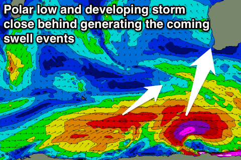
Our new S/SW groundswell for Thursday is still on track, with a tight and intense polar low forecast to develop to our south-west this evening, aiming a fetch of severe-gale to storm-force W/SW winds late in our southerly swell window.
This swell should peak Thursday morning to a good 4-6ft across the South West, but offer no real size around Perth.
Winds are set to be light and variable through the early morning, creating clean conditions before an approaching front brings an onshore W/SW breeze.
 The larger groundswell energy expected for Friday and Saturday is still on track as well with a strong node of the Long Wave Trough steering a couple of back to back polar fronts up through our south-western and southern swell windows through the middle to end of the week.
The winds in each front won't be as strong as the polar low, but each system will be working on the active sea state from the one before, generating a couple of pulses of large swell.
The first from the SW should fill in Friday and build to a strong and large 6-8ft across exposed breaks in the South West later, holding a similar size Saturday morning, and then slowly ease into the afternoon and further Sunday from 6ft range.
Perth isn't due to see any size until Saturday with inconsistent 2ft sets, easing back from 1-2ft Sunday.
Conditions Friday are average with a W/SW tending S'ly breeze, possibly opening up protected locations late, but Saturday looks great as ridge of high pressure builds from the west, resulting in winds swinging offshore from the E/SE.
Sunday should be clean again with an E/NE offshore ahead of afternoon sea breezes.
Longer term there's nothing significant due through next week, with another large groundswell on the cards for the following weekend. More on this Wednesday.

