S/SW swell energy for the coming period
Western Australia Surf Forecast by Craig Brokensha (issued Monday 21st March)
Best Days: Tuesday morning, Wednesday morning, Thursday morning, early Friday, Monday next week onwards
Recap
3-4ft of S/SW swell most of the weekend with decent winds through the morning across the South West. Perth and Mandurah were tiny.
Today started small and in the 3ft range with straight offshore winds, but a new S/SW groundswell should be filling in this afternoon although with fresh sea breezes.
This week and weekend (Mar 22 - 27)
This afternoon's kick in S/SW groundswell should reach 4-6ft across exposed breaks later in the day, and ease from a similar size across the South West tomorrow. The short-range S/SW swell due to replace it tomorrow has been downgraded with the front being weaker, with the easing groundswell being larger in size.
The less consistent energy for Wednesday is still on the cards through, keeping exposed breaks kicking around 3-5ft.
With the downgrade in the short-range S/SW swell, Perth is only now expected to see sets to 1-1.5ft tomorrow, fading Wednesday.
Winds are due to swing back to the SE and be fresh tomorrow morning, with better E/SE offshores into Wednesday, strengthening through the afternoon and tending a touch more SE.
Thursday should be fun with weaker E/SE offshores persisting all day as a reinforcing SW swell keeps sets up around 3-5ft, before fading into the afternoon, down further from 3ft+ Friday morning as winds tend more NE-N/NE.
Into the weekend, some S/SW swell should spread up from less than favourably aligned pre-frontal W/NW fetches through our south-western swell window mid-late this week.
This should keep exposed breaks in the South West active in the 3ft+ range Saturday and Sunday but with onshore NW and then SW winds as a weak low forming offshore drifts east.
Next week onwards (Mar 28 onwards)
Through the weekend the storm track will remain focussed towards Victoria and Tasmania, with polar frontal systems forming too late in our swell window to generate any major size.

Small S/SW groundswell will result with favourable winds from Monday.
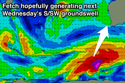
Of greater significance is a late forming but significant polar frontal system to our south-southwest, with an elongated fetch of severe-gale to storm-force SW winds due to be generated on the edge of our swell window.
A large S/SW groundswell should result, filling in Wednesday and peaking to a solid 6-8ft across the South West, maybe 1-2ft up at Perth, but check back here on Wednesday for how this swell is tracking.

