S/SW swell and tricky winds
Western Australia Surf Forecast by Craig Brokensha (issued Monday 18th January)
Best Days: Protected spots in the South West Tuesday, Wednesday and Thursday morning (keep expectations low), Friday morning exposed breaks in the South West
Recap
Clean but small to tiny surf Saturday morning ahead of a slight kick in new swell through the day. Sunday saw more size but poor conditions with a fresh onshore wind.
Today a mix of better SW groundswell and localised S/SW swell have peaked around the 4-5ft range with early onshore winds swinging offshore as the low responsible shifted east.
Mandurah saw a touch more size to 1-2ft this morning, with tiny 1ft+ waves around Perth.
This week (Jan 19 – 22)
Tomorrow should see a mix of easing SW groundswell and short-range S'ly swell but the low will move back in from the west bringing fresh to strong SE winds (possibly E/SE at times) to Margs, with light to moderate N/NE winds around Perth and Mandurah.
There'll be no size to the north, with fading 3ft to possibly 4ft sets max in the South West.
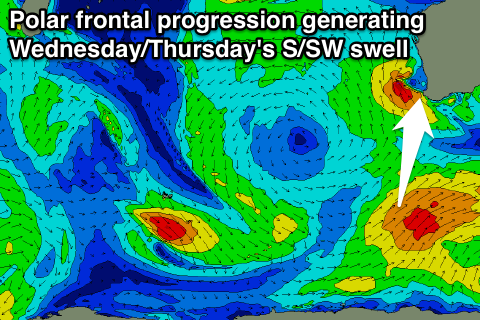
 Our pulse of S/SW groundswell for Wednesday and Thursday morning is looking good with with a strong polar frontal progression firing up to our south-west, projecting a fetch of SW gales through our southern swell window.
A good S/SW groundswell should be generated, building to 4-5ft through the afternoon at exposed breaks before easing from a similar if not slightly smaller size Thursday morning, further into Friday. Perth isn't due to see any real size at all with tiny 1ft waves max through Wednesday and Thursday.
Strong SE winds will limit the best surf to protected spots Wednesday, with fresh SE winds Thursday (not the best combo with a S/SW groundswell).
Friday should see better E/SE offshores but a small easing swell from 3ft+ or so.
This weekend onwards (Jan 23 onwards)
As touched on last update, a large blocking high moving in this week will deflect any major swell generating systems away from us through all of this week with no significant swell due at all into the weekend and next week.
Check back Wednesday for an idea when we may see things change.

