Mix of swells and conditions, larger swell for next Wednesday
Western Australia Surf Forecast by Craig Brokensha (issued Wednesday 28th October)
Best Days: Swell magnets early tomorrow in the South West, Sunday morning, possibly Monday morning, Wednesday
Recap
Clean fun 3-4ft sets across the South West yesterday morning, with tiny waves further north. Today the swell was around a similar size and good again with offshore winds but sea breezes have since kicked in across the South West.
This week and weekend (Oct 29 – Nov 1)
Similar waves are due to continue across the coast tomorrow with clean 3ft to occasionally 4ft waves across the South West and tiny 0.5-1ft waves up around Perth.
Get in early around Margs though as dawn E/NE breezes are due to tend more N/NE through the morning before swinging NW into the afternoon.
Friday will see more size with the arrival of a new SW groundswell (4-5ft Margs, 0.5-1ft Perth) but conditions will be poor under strengthening N/NW winds.
Saturday will see a mix of easing SW groundswell from Friday along with a slight kick in new W/SW tending SW swell for the afternoon.
This will be generated by a strengthening but south-east tracking low to our south-west on Friday, with a quick burst of SW gales being generated in our swell window.
Margs should pulse to 4-6ft later in the day but with S/SW winds. Sunday will be the better day to surf with the easing swell from 4-5ft through the morning under offshore E'ly winds. Perth won't offer any real size with clean 1ft sets.
A new long-range SW groundswell is still on track for the late afternoon, generated west of Heard Island yesterday and this morning, with the storm currently weakening while pushing further east across Heard Island.
The South West should kick to the 6ft range later in the day, with Perth not seeing any decent size before dark, with a drop due Monday from 5-6ft and 1ft to occasionally 2ft respectively.
Winds are still a little up in the air for Monday morning, with the latest GFS update indicating that a weak S/SW change may move through. We'll have confirmation regarding this on Friday.
 Next week onwards (Nov 2 onwards)
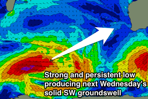
Of greater importance into next week besides easing swell and onshores, is a larger SW groundswell event on the cards for Wednesday.
The models are in agreement regarding a broad and vigorous polar low developing south-east of South Africa and pushing east across the Heard Island region while aiming a fetch of gale to severe-gale W/SW winds through our swell window.
The longevity of this low is great, with it due to continue close to project close to us early next week.
A large SW groundswell should result, filling in Wednesday and peaking through the afternoon to 8-10ft in the South West and 2ft to possibly 3ft around Perth. Winds are a little tricky at this stage but could be light offshore, we'll have another look at this on Friday though.

