Easing in surf with less perfect winds
Western Australia Surf Forecast by Craig Brokensha (issued Wednesday 7th October)
Best Days: Friday morning, protected spots Saturday morning, Sunday morning,
Recap
Pumping surf across all coasts yesterday with a rapidly improving large swell with winds swinging offshore cleaning up 10-12ft sets in the South West, 3-4ft waves around Mandurahe and 3ft surf up at Perth. Weak sea breezes impacted the South West, while Perth remained clean into the evening.
Today the swell was smaller but a reinforcing SW pulse has kept 8-10ft waves hitting the South West and 2-3ft waves around Perth with strong and tricky E/NE winds. These winds should ease into the afternoon while tending more N/NE.
This week and weekend (Aug 8 - 11)
Tomorrow isn't looking as nice as the last couple of days as a weak change moves through resulting in S/SE winds across the South West, E/SE around Perth.
The Surf will be smaller and back to 4-5ft across the South West with 1-2ft sets around Perth, holding a similar size into Friday morning as winds swing further offshore from the E/SE across Margs, and E/NE up around Perth.
Later in the day when sea breezes are due, a strong but inconsistent pulse of SW groundswell is due.
This has been generated the last couple of days by a strong but small polar low firing up in the Heard Island region.
We should see exposed breaks in the South West kicking to 5-6ft later in the day, with Perth likely not seeing any size before dark.
A drop in swell is then due Saturday from an inconsistent 4-5ft and 1-1.5ft respectively. Another weak trough is expected to bring less than favourable S/SE winds to the coast Saturday morning (E'ly around Perth), fresher from the SE Sunday (E/NE Perth).
Next week onwards (Oct 12 onwards)
Nothing too special to talk about early next week with an easing swell and E/SE offshores Monday morning and then moderate pulses of W/SW swell but with S/SE winds Tuesday and Wednesday.
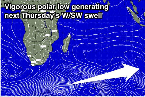
 A very inconsistent but strong long-range W/SW groundswell is due into Thursday though, generated by a vigorous and slow moving polar frontal progression under South Africa tomorrow and Friday, weakening under Madagascar Saturday.
Although in our far swell window, a large and inconsistent long-period W/SW groundswell should result, with the fore-runners arriving through Wednesday ahead of the bulk of the swell Thursday, peaking to 6ft to occasionally 8ft across the South West and 1-2ft around Perth.
Winds are possibly a little dicey though and light to moderate from the W/NW, we'll have a closer look at this on Friday though.


Comments
Hey Craig, checking the BOM marine winds map (http://www.bom.gov.au/marine/wind.shtml?location=wa-per&tz=AWST) for Sat it is showing NE winds early, but it seems you don't agree with this? there also seems to be a kick in period around Fri lunch which says to me it would be a little more consistent Sat. Just trying to decide the best day to try and get a wave between Fri and Sat north of Perth.
I'm thinking E/SE tending E/NE ahead of sea breezes around Perth (thought I'd added this in but I left out, there now).
Saturday will have the long-range inconsistent SW groundswell and I'd be hitting this instead of the background swell for Friday morning.