Moderate swell pulses with tricky winds
Western Australia Surf Forecast by Craig Brokensha (issued Monday 27th July)
Best Days: Protected northern corners Tuesday in the South West, dawn Wednesday, protected spots Thursday, Friday morning swell magnets, Saturday and Sunday
Recap
Average onshore waves across the South West Saturday with a building swell, cleaner and small to the north. Sunday was the day to surf with the swell easing under offshores across all locations.
This morning the South West was back to a small 3ft, with tiny waves further north.
This week (Jul 28 – 31)
The surf will remain small into tomorrow with good winds for protected northern corners in the South West from the N/NE.
Into Wednesday we've got a good pulse of SW groundswell due, generated by a strengthening polar frontal progression forming east of Heard Island over the weekend.
The swell should peak during the afternoon in the 6ft range across the South West, with 2ft sets in Perth, and a peak Thursday morning in the North West to 3-4ft+.
Winds early Wednesday look as if they'll be variable across Margs and Perth, with an increasing W/NW'ly through the day.
A S/SE change is then due through Thursday favouring protected spots as the swell eases.
Unfortunately there's no major swell due into the end of the week, and fresh to strong E/SE breezes will create tricky conditions at exposed locations in the South West Friday.
 This weekend onwards (Aug 1 onwards)
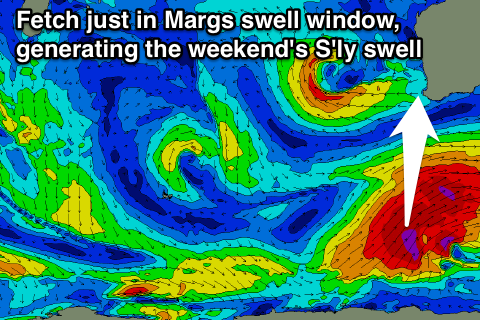
Into the weekend, an acute S'ly groundswell is due across the South West, with it not really impacting Perth at all.
This will be generated by a vigorous polar frontal system forming late in our swell window, to the south-southwest of the state. A fetch of gale to severe-gale S/SW winds will be generated just within Margs swell window, with a long-period pulse of S'ly swell due to arrive Saturday and peak into the afternoon.
Exposed breaks should see 4-6ft sets, before easing back rapidly into Sunday.
Winds will be strong offshore from the E/SE with a stationary and strong surface trough sitting offshore to our west, with winds likely to tend more SE as it moves in across us.
Longer term there's still nothing major on the cards, as a large blocking pattern setups up to our west. This doesn't look to change anytime in the next weekend and a half or so, but we'll review this Wednesday.


Comments
Decent bomb at Margs.