Good Tuesday, large and dangerous Friday/Saturday
Western Australia Surf Forecast by Craig Brokensha (issued Monday 28th June)
Best Days: Tuesday morning, Friday/Saturday/Sunday for experienced surfers only, Monday, Tuesday
Recap
Generally poor weekend of surf with onshores and an easing swell Saturday and then stronger onshores Sunday and a building stormy swell.
Today the solid S/SW windswell was still stormy in the South West to 6-8ft, with protected spots the pick for keen surfers, while Perth was workable with 3ft of bumpy cross-offshore peaks.
This week and weekend (Jun 23 - 28)
Tomorrow is the day to surf across the South West before the larger swell into the end of the week.
A new long-period S/SW groundswell should fill in later this afternoon across the South West and then ease back from 5-6ft+ across exposed exposed spots tomorrow morning, 2ft in Perth and the swell should fill in across the North West and reach 3-5ft into the afternoon before easing Wednesday from 3-4ft.
Winds are due to be light offshore from the E/NE before tending a little N'ly through the day and then N/NW into the afternoon. Perth and the North West should see favourable winds all day.
Come Wednesday when the swell becomes smaller strengthening NW winds will write-off the South West, while Perth will be clean and tiny, the North West fun early.
Of much greater importance is what's currently happening in the Indian Ocean.
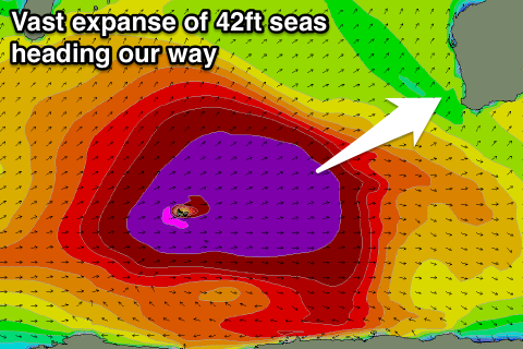
 A strong node of the Long Wave Trough is currently south-east of South Africa and moving slowly east. With this an intense polar low has developed, already generating a tight fetch of 50-60kt winds in our swell window.
This has set in motion an active sea state for a secondary broader and huge fetch of weaker severe-gale W/SW winds to move over, the size nearly reaching that of Australia.
This fetch will be slow moving with a series of large W/SW and then SW groundswell pulses due from late Thursday through until Saturday, slowly tailing off into early next week.
The long-period but inconsistent fore-runners are due to arrive Thursday morning around 25 seconds, with the swell building through the afternoon and reaching 6-8ft+ later in the day across the South West, 2ft in Perth and more so after dark in the North West.
Come Friday we're looking at the first oversized pulse of W/SW groundswell filling in, reaching a peak to 12-15ft across exposed breaks, with much larger sets at offshore reefs and bommies.
Perth should see the swell build to 3-4ft, with some rare bombs possible at swell magnets. The North West should kick to 10-12ft Friday afternoon and peak Saturday to 10-12ft+ or so.
A secondary large SW groundswell pulse is then due through Saturday morning, generated by the backside of the polar frontal progression and this should only come in a touch under Friday's size.
A slight drop is then due into the afternoon and then more noticeably through Sunday and Monday.
Now, winds. Thursday is poor with continuing fresh NW winds in the South West and N/NE to N/NW winds around Perth (NE tending N/NE up in the North West), while come Friday a ridge of high pressure is due to move in with offshore E/SE breezes around Perth and the North West and then fresh dawn S/SE winds around Marg, easing and tending SE through the morning and variable into the afternoon.
Come Saturday conditions are looking perfect with moderate to fresh offshore E/SE winds, tending variable into the afternoon (E/NE up in the North West).
Into next week offshores are due to continue, creating excellent conditions across the state. We'll delve into the longer term next update.

