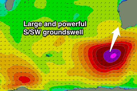
Large swell, cleanest as it eases Friday
Western Australia Surf Forecast by Craig Brokensha (issued Wednesday 27th May)
Best Days: Thursday, Friday, Saturday and Sunday at exposed breaks, most of next week besides Monday
Recap
A mix of swells to 2ft on the sets around Perth and Mandurah yesterday with generally light winds, while Margs was in the 4-5ft range with improving conditions as onshore SW winds tending more S/SE into the afternoon.
Today a new SW swell from a weak low sitting to our south-west produced a better swell to 4-6ft this morning in the South West with 2ft sets continuing further north. Winds were favourable around Perth and Mandurah but far from ideal around Margs with a dawn SE tending S'ly breeze, and then onshore wind mid-late morning.
 This week and weekend (May 28 - 31)
All attention shifts to tomorrow, with a large, powerful and long-period S/SW groundswell due to fill in strongly across the state, peaking through the middle of the day in the South West to 10-12ft at exposed breaks with bigger sets at offshore reefs.
Perth should build to 3ft on the sets into the afternoon, with Gero kicking late to 5-6ft.
A drop in size is then due through Friday from 6-8ft+ at exposed breaks in the South West, 2-3ft in Perth and 5-6ft around Gero.
Come Saturday the swell will be back to the small to moderate range, easing off further Sunday.
Conditions aren't looking the best around Margs tomorrow with a S/SE breeze due all day, favouring protected locations. Perth and Margs look better with offshore E/SE tending SE winds.
Come Friday though, Margs will be pumping with offshore E'ly winds that will more than likely tend variable into the afternoon. Saturday and Sunday are expected to play out similarly with morning offshore winds and light variable breezes into the afternoons.
Next week onwards (Jun 1 onwards)
Next week will start out slow with no real decent swell and dicey winds Monday, improving through Tuesday.
A new long-range but good W/SW groundswell is due through the middle of the week though, generated by a really strong and unfavourably tracking polar low south-east of South Africa during tomorrow and Friday.
This should produce an inconsistent swell to an inconsistent 5-6ft across the South West Tuesday afternoon with 1-2ft sets in Perth and 3-5ft up at Gero, with a more consistent pulse Wednesday. This should be produced by a better aligned and weaker frontal system racing towards us over the weekend.
This should looks to be more in the 6ft+ range into Wednesday afternoon around Margs, 2ft in Perth and 4-5ft up at Gero.
Beyond this a series of larger groundswells are on the cards for the end of the week and into the following weekend, associated with a strong node of the Long Wave Trough moving in through the southern Indian Ocean, but more on this Friday.


Comments
Some incredible readings on the Albany Buoy this morning, thanks Cam for bringing it to my attention.
7.5-8m of swell at peak periods of 20s (red arrow)
Craig i really think you should adjust your size calls for the exposed reefs . 10-12ft could move up a notch . Those reefs could really be 20-30 ft today.
Yeah a select few could be when it peaks.
But I had 10-12ft for most breaks, with larger sets at offshore reefs (pointing towards the 15ft range).
Naturaliste has hit 4m and possibly peaked? It won't get as big as Albany way.
You are good with your forecasts craig but to prove you wrong again i checked your albany forecast and its saying 12-15ft max . 7.76 @ 20 sec ? Thats More like 3 @ 20 ... Dont argue today has overachieved & we know it . Sorry bro , check windguru S B & see how much better you are than them bullshitters .
No totally agree, especially for the southern WA coast, Margs looks about on forecast though.
And yeah the algorithm for Albany and other exposed breaks in that region needs to be changed to reflect the size more, this has been on the cards for a while but hasn't been pushed through yet.
Yeah i just thought today would be a good moment to bring that topic up . Although it keeps the crowds low . All the msw & BW & WG are really wrong here but i should keep that quiet haha . Some of the numbers could be doubled or tripled in reality . In contrast when i check msw princetown its got huge numbers ! You need the knowledge to calibrate yourself like always.thanks craig hope we get variable winds
Did you get amongst it at cow bommie today caml? Looked pretty chunky from the safety of the shore.
Sea br and sn are my go to combo... keep it up Craig. How was Margs this pm! Absolutely frickn mental. Anyone check nth pt? RDO tomorrow. ......yewwww!
Got the word that cows had a coupla of bombs but wind was a bit choppy.nth pt had a few even tho swell was sth . not @ margrets & yeah sea br is good for swell there. But the beach im at has way diffrent calibration . Further away to the sth