Great Wednesday, easing into the weekend
Western Australia Surf Forecast by Craig Brokensha (issued Monday 18th May)
Best Days: Tuesday protected spots in the South West, Wednesday everywhere, Thursday through Saturday in Gero and around Margs
Recap
Average waves for the most part, although Perth saw plenty of size Sunday with a stormy windswell and strong onshore winds.
Today the low responsible for the poor weather and wind has slipped south-east resulting in a new SW swell improving in protected locations with S'ly winds. Margs was in the 4-6ft range, with 2-3ft surf around Perth, which has since eased.
 This week (May 19 - 22)
Today's SW swell should continue to drop out of the S/SW tomorrow from the 4ft range on the sets in the South West and 1-1.5ft in Perth as winds improve and swing SE.
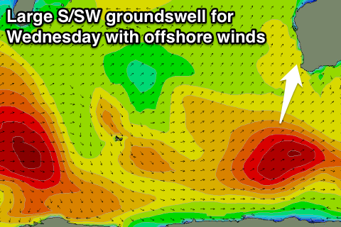
A new large S/SW groundswell should show late across the South West and peak Wednesday morning, generated by a strong polar frontal system that formed to our south-southwest over the weekend.
This swell will be fairly southerly in nature, with exposed breaks in the South West due to peak Wednesday morning to 6ft to occasionally 8ft and 2ft on the sets in Perth. Gero should see 3-4ft+ waves.
Winds will be great for this swell and offshore from the E/NE all day.
A drop in size should then be seen into the afternoon and further Thursday and Friday. A small reinforcing S/SW groundswell for Friday morning will soften this easing trend, but only keep 3ft to possibly 4ft sets hitting exposed breaks during the morning in the South West.
Winds should persist from the E/NE both Thursday and Friday, favouring exposed locations in the South West.
This weekend onwards (May 23 onwards)
Nothing major is due on Saturday, but come Sunday and into early next week, a couple of relatively weak frontal systems are due to push into the southern corner of the state. This should produce moderate amounts of W/SW swell for Sunday followed by SW swell later Monday/Tuesday but with poor onshore winds. More on this Wednesday though.

