Onshore winds and average swells, cleaner from Tuesday
Western Australia Surf Forecast by Craig Brokensha (issued Wednesday 13th May)
Best Days: Thursday morning protected spots in the South West, Tuesday morning onwards in the South West
Recap
A fun pulse of SW groundswell yesterday to 4-5ft+ across the South West under all day offshores, while Perth and Mandurah saw slow and inconsistent but fun 1ft to occasionally 2ft sets. Gero was good and clean all day as well. Today the swell was on the ease as offshore winds continued across all spots.
 This week and weekend (May 14 - 17)
The end of this week isn't looking too flash with strengthening N/NE winds through tomorrow and a small easing swell from 2-3ft while a better W/SW groundswell is due Friday but with fresh to strong N/NE tending N/NW winds.
The N/NW windswell that was due to be generated from an approaching and intense mid-latitude low has been downgraded in size a touch, with the easing W/SW swell from Friday being more dominant.
A mix of swells to 3-5ft is due in the South West with 2-3ft surf around Perth from the NW but with fresh to strong NW winds.
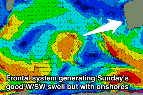
Into Sunday we're looking at a building mix of longer-range W/SW groundswell from the initial stages of the mid-latitude low when its north-east of the Heard Island region today and tomorrow.
This swell should kick to 4-6ft through the day Sunday in the South West and 2-3ft in Perth with 3-5ft waves up at Gero, but a local W/SW windswell will also be in the mix which at this stage looks to be larger but along with poor NW winds Sunday and then W/NW tending W/SW winds Monday.
Next week onwards (May 18 onwards)
Into early next week the W/SW swell from the mid-latitude low is expected to ease but we should see a new S/SW groundswell for later Monday and Tuesday morning.
This doesn't look to provide any major size with 3-5ft sets in the South West and 1ft waves up in Perth ahead of a secondary similar size SW groundswell for Wednesday.
Winds should improve from Tuesday with winds swing offshore from the E/SE with straighter E'ly winds Wednesday.
Longer term we should see some larger swell activity into later next week/weekend as a new node of the Long Wave Trough starts pushing in from the west, but we'll look at this again on Friday.

