Good swells to come, cleanest as they ease
Western Australia Surf Forecast by Craig Brokensha (issued Wednesday 29th April )
Best Days: Friday in protected spots, Saturday morning, Monday in protected spots, Tuesday morning, Wednesday morning
Recap
Small clean waves across Margs yesterday and tiny to flat glassy waves across Perth and Mandurah. Today the swell is around the same size but a new swell is due to build through the afternoon but with average N'ly winds.
This week (Apr 30 – May 1)
This afternoon's increase in long-range SW groundswell should be replaced by a better SW pulse tomorrow, reaching 4-6ft across the South West into the afternoon and 1-2ft up in Perth. Conditions will be poor though with a moderate W/NW-NW breeze ahead of a late W/SW change. Perth should be cleaner through the day with increasing onshores after lunch.
A better pulse of SW groundswell for Friday is still on track, generated by a relatively weak frontal system currently sitting to our south-west.
This swell should build through the day Friday and reach 6ft+ across exposed breaks with 2ft+ waves up in Perth. Gero should come in at 3-4ft into the afternoon.
Protected locations are still the pick though as winds swing to a moderate to fresh S/SE'ly across Margs with S/SE tending SE breezes around Perth.

This weekend onwards (May 2 onwards)
Saturday will be much cleaner on the backside of the swell with light E'ly offshores across most regions (NE up at Gero) and an easing swell.
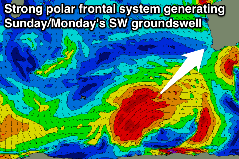
Sunday afternoon's kick in large SW groundswell is still on track, with a peak due Monday across the state.
This SW groundswell will be generated by a vigorous and two pronged polar frontal system firing up from the Heard Island region today, towards us under the effects of a strong node of the Long Wave Trough.
A fetch of weakening but broadening severe-gale SW winds will be generated from today through Friday followed by a secondary push up towards us Saturday and Sunday.
A large SW tending S/SW groundswell should result, building Sunday to 8-10ft late in the day in the South West, 2ft+ up around Perth and 3-4ft at Gero.
A peak is then due Monday to 10-12ft+ in the South West, 3ft in Perth and 5-6ft+ up at Gero.
Winds on Sunday will be poor and strengthening from the SW with better but still average S/SE winds into Monday.
Tuesday will be the day to surf as the S/SW swell eases under offshores across all locations.
From Wednesday there's nothing significant expected at all but winds will be favourable for exposed breaks in the South West.
The next considerable swell is likely during the middle of May, but more on this Friday.

