Fun Sunday morning, smaller next week
Western Australia Surf Forecast by Craig Brokensha (issued Friday 6th March)
Best Days: Saturday morning exposed breaks, Sunday morning all coasts, Monday morning all breaks, Thursday morning
Recap
Smaller but fun waves across exposed breaks yesterday with offshores that held all day around Perth and Gero.
Today a new mix of inconsistent W/SW groundswell and SW groundswell have filled in offering good 3-4ft sets across the South West, 1-2ft sets in Perth and 2-3ft sets at back beaches in Gero.
This weekend (Mar 7 - 8)
Today's mix of swells are due to ease back through tomorrow from an inconsistent 3ft to occasionally 4ft in the South West, 1-1.5ft in Perth and 2ft+ up at Gero.
Winds look good and offshore from the E/SE through stages of the morning in the South West and E/NE winds around Perth and Gero.
Sunday's strong but inconsistent kick in long-range W/SW groundswell from a very strong and intense but unfavourably tracking low over near Heard Island earlier this week is still on track.
This swell should arrive overnight Saturday and peak at an inconsistent 4-6ft across exposed breaks in the South West, 2ft on the sets in Perth and 3-4ft up at Gero.
Winds won't be as favourable and from the SE around Margs through the morning, with better E/NE winds up at Gero and E'ly offshores in Perth before a strong S'ly change pushes through.
 Next Monday onwards (Mar 9 onwards)
A secondary pulse of SW groundswell from the low that generated the W/SW swell is due to arrive overnight Sunday, buffering the easing trend into Monday.
Margs should ease from 3-5ft, with 1-2ft sets in Perth and 3ft waves up at Gero under better E/SE offshore winds (E/NE up at Gero).
The swell should continue to ease into Tuesday with less favourable S/SE winds around Margs and offshores E'ly winds further north.
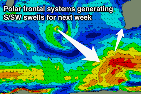
As touched on last update, we'll see fun pulses of S/SW groundswell across the South West, but Perth and Gero won't see any major size due to the southerly direction and the swell being mainly side-bad energy that's more focussed into SA and Victoria.
The strongest pulse is due through Thursday but only to 3-4ft+ or so across exposed spots in Margs, with 2-3ft sets up at Gero before easing into the end of the week.
Winds are looking good with E'ly offshores across all coasts Thursday but we'll have another look at this on Monday.
Longer term there's nothing too major on the cards, so make the most of the swell due over the weekend. Have a good one!

