Good north of Margs next two days, large swell for Saturday
Western Australia Surf Forecast by Craig Brokensha (issued Monday 6th October)
Best Days: Tuesday and Wednesday north of Margs, Thursday onwards everywhere
Recap
The South West saw poor conditions all weekend, with a bigger swell and S'ly wind this morning opening up a few options. Perth and Gero saw cleaner conditions Saturday morning, but today was the pick with a solid and clean 3ft+ of swell around the metro beaches and 4-6ft waves up at Gero.
This week and weekend (Oct 7 - 12)
Today's swell will ease off through tomorrow as unfavourable and fresh NW winds linger around Margs, while Perth and Gero should offer cleaner conditions with offshore E/NE winds.
A moderate increase in W/SW groundswell is due across the state Wednesday afternoon, dropping through Thursday but onshore winds will continue to create poor conditions in the South West Wednesday.
Thursday will be better around Margs with the swell easing from 4-5ft under S/SE winds, while Perth should be around 2ft and 3-4ft up at Gero but not that special with the southerly winds.
As touched on the last few updates, a large SW groundswell for late in the week and more so Saturday is right on track, with a strong node (peak) of the Long Wave Trough expected to move across us through Thursday and Friday.
 Firstly though the LWT has helped produce a large long-period SW groundswell from the south-east of South Africa with this due to arrive late Friday and pulse to 8ft in the South West, 2-3ft in Perth and 3-5ft up at Gero.
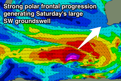
Saturday will see a closer-range SW swell filling in though, generated by strong polar frontal activity firing up to our south-west from tomorrow through the rest of the week, producing a better 10ft of swell for the South West, 3ft sets in Perth and 5-6ft+ up at Gero.
Winds at this stage look good and from the SE Saturday morning and then possibly E/SE Sunday as the swell eases, but we'll confirm this on Wednesday.

