Great weekend, early Friday the pick next week
Western Australia Surf Forecast by Craig Brokensha (issued Friday 27th June)
Best Days: Saturday, Sunday, early Monday, Thursday morning, Friday morning
Recap
Strong onshore winds wrecked a large and powerful W/SW groundswell across the state yesterday with no decent options besides super protected bays and points in selected spots.
Today Margs improved with a renewal of large SW groundswell under moderate to fresh S'ly winds while Perth performed best with light E/SE offshores and 3ft sets.
This weekend (Jun 28 - 29)
Today's large SW groundswell should ease off through the weekend as winds clock offshore, swinging light E/SE in the South West with an easing 6-8ft+ of swell. Further north conditions should be much straighter with a moderate E'ly around Perth as the swell eases from 2ft to nearly 3ft and fresher E/NE winds around Gero with 5-6ft of swell.
Sunday should be great at more exposed locations with fresh and gusty E/NE winds.
Next Monday onwards (Jun 30 onwards)
A small lift in inconsistent SW groundswell is due on Monday and this should come in at 4-5ft+ around Margs, 1-2ft in Perth and 3ft+ up at Gero but fresh and gusty N/NE winds will limit surfing options.
Tuesday won't be much better as winds remain fresh to strong from the N/NE and the swell eases.
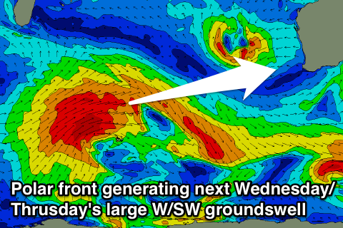
 As touched on last update, a large W/SW groundswell is due later Wednesday and Thursday across the state, generated by a broad and vigorous polar front firing up over to top of Heard Island during today and over the weekend.
Initially on Wednesday winds will be poor and from the N/NW tending SW but the frontal system linked to the onshore change will clear off quickly to the east and we should see winds returning to the S/SE Thursday morning around Margs and SE further north.
Size wise Margs should ease from 8ft to possibly 10ft, 2-3ft in Perth and 5-6ft around Gero. Friday morning should be cleaner but it will be a small window of opportunity as winds veer from an early E/NE'ly around to the N/NE through the day.
Longer term the models diverge on a large mid-latitude low forming in the Indian Ocean, so we'll have to look at this again on Monday. Have a great weekend!

