Great surf developing through the weekend

Victorian forecast by Craig Brokensha (issued Wednesday April 2nd)
Best Days: Today both coasts, Friday afternoon Surf Coast, eary Saturday Surf Coast, Sunday Surf Coast
Features of the Forecast (tl;dr)
- Smaller tomorrow with W/NW tending S-S/SW winds around midday
- Moderate sized mix of W/SW and SW swell for Fri PM (undersized early) with moderate SW tending W/SW winds (W/NW early Surf Coast)
- Moderate sized mix of swells Sat with fresh W/SW-SW winds (W/NW likely early Surf Coast)
- Large SW groundswell building Sun, peaking in the PM, with a reinforcing pulse for Sun
- Strengthening N/NW tending W/NW winds Sun, with strong SW winds Mon
- Moderate SW winds Tue with easing surf (likely W/NW early Surf Coast)
Recap
Winds eased and shifted more east through yesterday though the Surf Coast remained a blown out mess with a new groundswell in the mix being hard to decipher. Locations to the east were cleaner but a bit straight with the morning low tide and also a bit too sizey.
This morning the surf has eased off a little and conditions are best to the east again but not great with the mid-morning low tide. The Surf Coast was still fairly average and best on the beaches. Winds are due to go more variable on the Surf Coast this morning, creating improving conditions ahead of weak sea breezes.
This week and weekend (Apr 3 - 6)
The current easing swell will continue to fade into tomorrow and a morning W/NW breeze will create clean conditions on the Surf Coast but with 2ft leftovers. A weak trough will bring a S-S/SW change late morning or more so midday so surf before then.
Lingering SW winds are due Friday (W/NW early Surf Coast) with no increase in significant size due until the afternoon, when a new mix of inconsistent W/SW and SW swell are due to fill in. As touched on in Monday’s notes, the source of the W/SW energy was a strong low that projected towards Western Australia earlier this week, through our western swell window.

The SW swell is being generated by a great fetch of W/SW gales currently to the south of Western Australia, with both due to reach 3-4ft on the magnets across the Surf Coast into the afternoon with 6ft sets to the east and winds don’t look overly bad, tending more W/SW as the day progresses.
This will be ahead of an approaching frontal system - the head of a significant Southern Ocean frontal progression firing up under a strong node of the Long Wave Trough.
We’re set to see various fetches of gale to at times severe-gale W-W/SW winds generated through our south-western swell window from Friday evening through the weekend, generating building levels of SW groundswell that look to peak through Sunday/Monday.
Firstly, on Saturday we’ll see Friday’s swells easing but the front moving through during the day will generate some weak close-range SW swell energy to 3-4ft on the Surf Coast with 6ft sets to the east under a fresh W/SW-SW breeze. The Surf Coast will likely see early W/NW winds under this scenario.
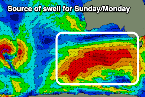
Sunday should see the first pulse of larger SW groundswell moving in, building through the day and reaching 6ft through the afternoon on the Surf Coast magnets with 8ft sets to the east. Conditions will be great all day with a strengthening NW tending W/NW breeze ahead of the final frontal system pushing through into the evening.
Unfortunately this looks to leave strong SW winds in its wake on Monday along with surf to 6ft+ on the Surf Coast and 8ft+ to the east.
Weaker SW winds should be seen on Tuesday with an early W/NW offshore for the Surf Coast as the swell backs off. We’ll confirm this on Friday, but at this stage Sunday looks like the pick of this swell event.
Longer term some good, longer range groundswells are due later next week/weekend, but more on this Friday.