Great few days of surf ahead

Victorian forecast by Craig Brokensha (issued Monday March 17th)
Best Days: Tomorrow ahead of sea breezes, Wednesday, Thursday
Features of the Forecast (tl;dr)
- Mod-large, easing SW groundswell tomorrow with local offshore winds and freshening SE sea breezes in the PM
- Moderate sized mid-period SW swell for Wed AM
- Stronger, less consistent SW groundswell for Wed PM, peaking overnight, easing Thu
- N/NE tending E/NE winds Wed
- Strengthening N/NW winds Thu ahead of a shallow W/NW change early PM, S/SW after dark
- Moderate sized W/SW-SW swell building Fri, easing Sat
- Moderate S/SE-SE winds Fri, possibly lighter but lingering S Sat
- Freshening SE winds Sun
Recap
Saturday was great across the exposed beaches with a small, fun swell and offshore winds, while yesterday a building SW groundswell ahead of an onshore change provided quality waves on the Surf Coast.
Today we’ve got a moderate to large spike in SW swell but with generally average to poor conditions across the region.
This week and weekend (Mar 18 - 23)
Following today’s onshore blow, we’ve got a great week of surf ahead with an improvement in winds from tomorrow along with plenty more swell energy through the middle to end of the week.
Today’s SW groundswell is due to peak this afternoon and start easing through tomorrow as winds go variable offshore across both regions, creating good, improving conditions ahead of freshening SE sea breezes into the afternoon.
The Surf Coast will be the pick with easing surf from the 4ft range, still solid and to 6ft+ to the east, while into the late afternoon but more so Wednesday morning, some new mid-period SW swell is due to arrive.
This will be ahead of an even stronger and better SW groundswell into the afternoon/evening, with the source being a healthy polar low that’s currently south of Western Australia.
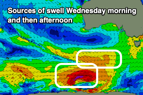
A good fetch of pre-frontal W/NW winds on the north-west flank of the low will generate the mid-period swell for Wednesday morning to 4ft on the Surf Coast magnets and 6ft to the east, while a fetch of severe-gale W’ly winds around the core of the low should produce the stronger groundswell.
This should build to a less consistent 5-6ft on the Surf coast with 8ft sets to the east through the late afternoon, easing Thursday from 3-5ft and 6ft+ respectively west and east of Melbourne.
Winds on Wednesday will favour selected spots with a morning N/NE breeze, shifting more E/NE through the day, while Thursday looks better for the Surf Coast as winds tend N/NW and strengthen ahead of a weak, shallow W/NW change early afternoon, and then stronger S/SW winds after dark.
The late change will be associated with a weakening polar frontal system projecting up and into us, with lingering S/SE-SE winds due into Friday morning along with a new increase in moderate sized mid-period SW swell generated by the earlier stages of the storm.
It looks like the Surf Coast should kick back to 3-4ft during the afternoon Friday before easing Saturday from a similar sized but with less consistency, while locations to the east will see 6ft surf.
The weather forecast models diverge regarding the local winds for Saturday but it looks like S’ly winds will linger, creating average conditions, freshening through Sunday from the S/SE-SE as another swell arrives but we’ll confirm this on Wednesday.
In any case there’s plenty of surf to capitalise on over the coming days.
Comments
Good forebanga