Good beachy waves from Friday, with a strong west swell for Monday
Victorian forecast by Craig Brokensha (issued Wednesday February 19th)
Best Days: Beaches Friday ahead of sea breezes, beaches Saturday, Surf Coast Monday morning
Features of the Forecast (tl;dr)
- Easing mix of swells tomorrow with mod-fresh S/SE winds, easing later
- Fun mid-period S/SW swell for Fri PM and Sat, easing Sun
- E/NE-NE winds ahead of mid-PM sea breezes Fri, strengthening N/NE Sat, tending NE into the PM
- Strong N winds Sun AM, easing slightly ahead of a strong SW change around midday
- Mod-large W'ly swell Mon with early W/NW (on the Surf Coast) tending S/SW winds
- Easing swell Tue with SE winds
- Cleaner but smaller Wed under a morning N'ly
Recap
Conditions were clean early yesterday on the Surf Coast with 2ft or so of swell before quickly deteriorating under freshening onshore winds.
Today we’ve got our new mix of W/SW and SW groundswells to 3-4ft on the Surf Coast and 5-6ft to the east, but onshore winds are continuing to create average conditions, only suitable for the keen.
This week and weekend (Feb 20 - 23)
Today’s mix of swells will ease into tomorrow and further Friday across the state, but some fun, mid-period S/SW swell is due into Friday afternoon and Saturday, generated by a healthy and elongated fetch of mostly strong W/NW-W winds moving along the polar shelf the last couple of days.
This should maintain 2-3ft sets across the Surf Coast into Friday and Saturday with 4ft to occasionally 5ft waves to the east before easing into Sunday from 2ft and 3-4ft respectively.
Local winds will remain poor tomorrow and moderate to fresh out of the S/SE, easing into the later afternoon and evening, with Friday coming in best under E/NE-NE winds, only giving into sea breezes around mid-afternoon out of the S/SE-SE.
Saturday will become windy but still good with strengthening N/NE winds that should tend back more NE into the afternoon and evening ahead strong N’ly winds and an incoming trough Sunday morning, easing temporarily ahead of a strong SW change around midday.
With the strength of the winds and easing swell, Friday and Saturday are the pick with Sunday morning being mostly a no go.

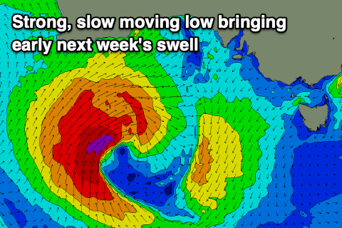
Now, on Monday, we’ve got a tricky W’ly swell due, thanks to a strong but northerly positioned mid-latitude low moving in from the west.
This low will form under Western Australia on Friday, with a fetch of strong to gale-force W/SW-SW winds just falling within our western swell window as it moves slowly east on Saturday, then closer towards us Sunday.
The low will deflect to the south-east of Monday, with a moderate to large sized mix of mid-period and groundswell due to fill in and peak in the 4-5ft range on the Surf Coast and 6-8ft on the Mornington Peninsula.
Local winds look W/SW to S/SW but a period of early W/NW breezes is likely on the Surf Coast Monday morning, with SE winds Tuesday as the swell eases.
Cleaner conditions with smaller surf is due on Wednesday but we’ll have a closer look at this Friday along with a secondary SW groundswell due late week.


Comments
Thanks Craigos. Going to be that annoying person and ask about size for Friday morning.
Same as you have above for the new swell or smaller in the morning? It's a touch and go size for certain areas. Cheers.
Ahhh yes, probably still 2-3ft. Could even be more in that upper range as pulses are a little hard to discern.
Another annoying person.
Are u saying 2-3’ to the east Friday am?
Nah Surf Coast.
Thanks Craigos.
thanks