Stormy run of SE swell ahead

Victorian forecast by Craig Brokensha (issued Friday February 7th)
Best Days: No great days, but tomorrow afternoon for the savvy, exposed beaches Tuesday and Wednesday mornings
Features of the Forecast (tl;dr)
- Moderate + sized SW groundswell tomorrow AM, easing later and further Sun
- Strong S winds early tomorrow, easing across all locations and becoming light to the east through the AM ahead of a strengthening SE tending E/SE wind
- Moderate + sized SE windswell Sun/Mon with strong E/SE-SE winds
- Easing SE windswell Tue with gusty E tending weaker E/NE winds ahead of S/SE sea breezes
- Small to tiny Wed with NE tending SE winds
Recap
Conditions were average at dawn yesterday but improved across both regions through the day as winds eased and turned more offshore to the east, weak onshore to the west. A mix of new swells came in at 3-4ft on the Surf Coast magnets with strong 6ft closeouts to the east, smaller today but with strengthening onshore winds making for generally poor surf.
This weekend and next week (Feb 8 - 14)
The trough responsible for today’s strengthening onshore winds will dominate the forecast period thanks to it lingering north-east of us on the weekend, squeezing high pressure that will slide in slowly from the west.
This will bring funky winds tomorrow, strong S’ly across most spots early, though easing as the day goes on with Phillip Island due see lighter S winds developing, then shifting SE into the early afternoon and then strengthening from the E/SE.
Either way conditions won’t really improve enough to offer any decent waves across exposed locations, but there might be a few in protected spots through the day thanks to the arrival of a moderate + sized SW groundswell.
As touched on through the week, this swell was generated by the remnants of Tropical Cyclone Elvis drifting south-east from around Madagascar before being absorbed into the westerly storm track.
A rapidly deepening low produced a great fetch of sever-gale to storm-force W/SW winds before weakening while tracking slowly towards us the past couple of days.
There’s no change to the expected size with the Surf Coast due to reach 4-5ft+ on the magnets tomorrow, 6-8ft to the east before easing into the afternoon, further Sunday.
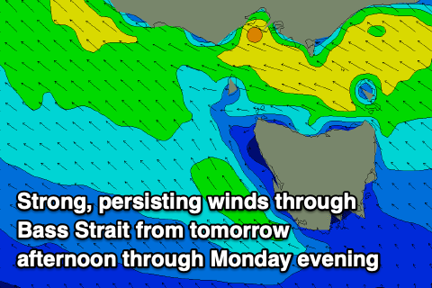
As the swell eases Sunday, strong E/SE-SE winds will kick up a stormy increase in SE windswell that looks to reach 4-6ft on the Surf Coast with smaller waves to the east, persisting Monday under similar strong E/SE tending SE winds.
As the high continues moving east through Tuesday/Wednesday next week, pressure gradients with the trough should weaken and allow strong but easing E tending E/NE winds into Tuesday morning but with a junky, easing windswell from 3ft+ on the Surf Coast, smaller to the east.
Wednesday will be cleaner under a NE breeze but there’ll be no real background SW swell in the mix for locations east of Melbourne, with stray 2ft sets likely.
The surf looks to bottom out into Thursday with offshore winds, while our next increase in swell looks to arrive later week as a deepening mid-latitude forms in the Bight.
At this stage a moderate sized mid-period SW swell is expected but with S’ly winds as high pressure moves in behind the swell generating system next weekend. More on this Monday. Have a great weekend trying to escape the wind!