Two quality swells inbound but with tricky winds

Victorian forecast by Craig Brokensha (issued Wednesday February 5th)
Best Days: Tomorrow from mid-morning, Surf Coast early Friday
Features of the Forecast (tl;dr)
- Moderate sized mix of inconsistent W/SW groundswell and more consistent mid-period W/SW-SW swells tomorrow, easing Fri
- Pre-dawn, fresh E/SE winds, easing and tending E/NE around dawn and the N/NE to the east through the morning, variable to the west. Weak sea breezes
- Light W/SW-SW winds Fri (likely W/NW early Surf Coast), strengthening from the SW through the day
- Moderate + sized SW groundswell for late Fri but more so Sat AM, easing
- Strong S/SW winds Sat AM, easing a touch then tending strong SE into the PM
- Strong E/SE-SE winds Sun/Mon with a moderate sized increase in SE windswell
- Winds easing Tue and tending E/NE with easing levels of windswell
Recap
Yesterday morning was good across all locations with Monday’s swell holding in a little better than expected. Local offshore winds created clean conditions before a strong onshore change moved in just before midday on the Surf Coast.
Today is poor with gusty onshore winds and a local increase in windswell.
This week and next (Feb 6 - 14)
The current, poor onshore winds will improve and swing offshore to the east through the morning tomorrow, variable to the west as a trough sitting north of us drifts south.
This will see pre-dawn E/SE winds easing and tending E/NE then N/NE to the east, weaker and more variable to the west.
Swell wise, a mix of different periods and directions are due thanks to a strong low that formed south of South Africa earlier last week, traversing the Southern Ocean towards us while slowly weakening and then having one final re-intensification south-west of us yesterday.
The Surf Coast should come in at 3-4ft on the magnets with 6ft sets to the east.
Afternoon sea breezes look to only be relatively weak so there should be a whole day of fun surf tomorrow before taking a turn for the worse on Friday.
The trough is due to shift back to the east and with this increasing SW winds are due on Friday with easing surf, but the morning should see lighter breezes, that may tend W/NW for a period on the Surf Coast.
Unfortunately the weekend will see strong S/SW winds persisting Saturday morning, possibly easing off a little before shifting SE and strengthening again as the trough retrogrades back to the west.
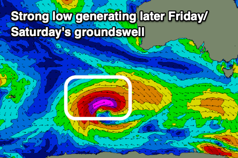
This will spoil a new, moderate + sized SW groundswell that’s due to arrive later Friday but offer the most size Saturday morning, easing through the day.
As touched on in Monday’s notes, the source is a strong low that formed south-west of Western Australia yesterday thanks to the remnants of Tropical Cyclone Elvis drifting south-east from Madagascar, being absorbed into the westerly storm track.
A great fetch of severe-gale to storm-force W/SW winds have been generated in our swell window and this should produce a strong kick in size with Saturday morning coming in at 4-5ft+ on the Surf Coast and 6-8ft to the east.
Sunday will be smaller but with a moderate sized increase in SE windswell thanks to strong E/SE-SE winds through Bass Strait, persisting Monday but shifting a little more E/SE.
It looks like winds will start to back off and shift E/NE through the morning Tuesday but there’ll be no groundswell in the water, just easing SE windswell.
Unfortunately the rest of the week looks minimal size wise which is a shame as winds look good for the beaches. More on this Friday.
Comments
How's the low tide!
Hey Benny what’s with these tides? Nothing crazy on the tide charts but cray on the shorelines
Pretty low.. yesty was 0.18m on the Surf Coast. Thought there might have been some assistance from the inverse barometer effect but pressure was 1012hPa which is about normal. Perhaps a slight effect from the recent easterly flow through Bass Strait? I haven't been watching closely though.
0.19m low is pretty low.
Good afternoon Senor Craigos - considering the lowest astronomical tides can get to around -0.3 in vicco pretty low but not crazy low. Must be the combo draining them tides right out. You wonder how much water that is when you consider all the nooks and crannies (lineal metres) of the vicco coastline. Bloody shitheap
The BOM OceanMAPS forecast does show negative anomalies of 0.1-0.2m around the coast at the moment
Near Lowest Astronomical Tides at moment combined with an easterly current moving through Bass Strait a likely contributor. Should see larger negative anomalies as the easterlies strengthen into next week.
Very interesting cheylo and good to have obs. Wonder what the local extent / variance is along the entirety of bass straight coastlines - let’s say Portland (if any), Cape Otway, Lorne, Torquay, Point Nepean, Gunna, Woolies, Wilson’s prom, Cape Conron etc Will need to look them up. 20cm on top of lowest AT is decent
Get a glimpse of the quality sand banks at Woolamai!
Good couple of days for scoping!