Make the most of the current surf

Victorian forecast by Craig Brokensha (issued Monday February 3rd)
Best Days: Today, tomorrow morning, selected spots Thursday
Features of the Forecast (tl;dr)
- Easing SW groundswell tomorrow with local offshore winds (N/NE to the east, N-N/NW to the west) ahead of a strong S/SW change by midday
- Strong S winds Wed
- Moderate sized mix of WSW-SW swells Thu with E/NE tending lighter NE winds ahead of relatively weak sea breezes
- Easing swell Fri with a SW change at dawn
- Strong S winds Sat with a moderate-large SW groundswell
- Easing groundswell Sun with light S/SW tending strong SE winds
- Building SE windswell Sun and Mon with strong SE winds
Recap
Conditions improved slowly over the weekend with Saturday morning coming in small and onshore on the Surf Coast with bumpy, workable waves to the east for the keen, while yesterday was much cleaner on the beaches to the east and also to the west with a mix of swells coming in at 5ft+ across the magnets, a peaky 3ft on the Surf Coast.
This morning started a touch slow at dawn but our new pulse of SW groundswell kicked shortly after with the Surf Coast now coming in at a stacked 3ft+ with 4-6ft waves to the east under favourable winds. Winds are due to shift more NE through the day and then variable into the afternoon/evening.


Good new swell in the water this morning
This week and weekend (Feb 4 - 9)
Today’s pulse of SW groundswell was generated by a tight, south-east tracking low, with it moving quickly through our swell window.
This will result in a short-lived spike of swell, easing back tomorrow from 2ft+ on the Surf Coast and 4ft or so to the east under local offshore winds (N/NE to the east N-N/NW to the west) ahead of a late morning S/SW change.
The change will be associated with a trough and leave strong but easing S’ly winds into Wednesday, making it a lay day.
We then look at our mix of mid-period W/SW swell and groundswell for Thursday, with the source being a strong low that formed south of South Africa last week, slowly moving east towards the country while weakening on the weekend.
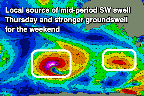
The remnants of this storm are now south of the country, still generating a healthy fetch of strong W/SW winds that will intensify slightly south-west of us tomorrow. This will add an additional SW component, with the mix of swells due to come in at 3-4ft on the Surf Coast and 6ft to the east, with the odd possibly bigger one.
Winds will improve and tend E/NE-NE on Thursday morning, favouring locations east of Melbourne ahead of relatively weak sea breezes, while a trough unfortunately looks to bring a SW change at dawn Friday as the swell eases.
The trough will unfortunately bring generally average winds for the weekend with strong S/SW breezes on Saturday due to shift SE on Sunday. There is a possible window of variable winds Sunday morning but we’ll review this in the coming updates.
A strong new pulse of SW groundswell, generated by a strong polar low firing up to the south-west of Western Australia this evening and tomorrow. This low will actually intensify as the remnants of Tropical Cyclone Elvis which was off Madagascar is absorbed into the westerly storm track.
A great fetch of severe-gale to storm-force W/SW winds should produce a moderate to large SW groundswell for Saturday to 4-5ft+ on the Surf Coast and 8ft to the east but with those poor winds, easing Sunday as strengthening SE winds kick up some localised windswell.
More on this Wednesday.