Good weekend for the beaches
Victorian forecast by Craig Brokensha (issued Friday January 17th)
Best Days: Beaches to the east tomorrow morning and Sunday, Monday morning for the keen, Tuesday morning to the east
Features of the Forecast (tl;dr)
- Easing W/SW swell tomorrow with a building SE windswell on the Surf Coast
- Strong E/SE-E winds tomorrow AM, tending SE into the PM
- Easing SE windswell Sun with a long-range, building W/SW groundswell, strongest late PM, easing slowly Mon
- Light NE-N/NE winds Sun ahead of mid-PM sea breezes
- Light E/SE winds Mon AM, freshening into the PM
- Smaller Tue with variable tending S winds
- Strong S/SW winds Wed, lingering S Thu
Recap
A fun mix of long-range W/SW groundswell and mid-period energy provided 3ft+ waves on the Surf Coast yesterday with 6ft sets to the east. Early W’ly winds favoured protected spots on the Surf Coast before shifting onshore and strengthening along with everywhere else.
This morning the swell has eased a little and winds are strengthening from the south, creating poor conditions across the region.
This weekend and next week (Jan 18 - 24)
The current onshore winds are linked to a trough moving through the region and we’ll see this merge into a broad, deepening Tasman Low to our east over the weekend.
This will see strong E/SE tending E winds developing through Bass Straight tomorrow, kicking up small to moderate levels of SE windswell for the Surf Coast to 2-3ft through the morning, bigger into the afternoon as winds shift SE.
Locations to the east should be cleaner and peaky with easing sets from 3-4ft, down further from yesterday’s swell.

Into Sunday winds will improve further for locations to the east of Melbourne, easing and tending NE-N/NE through the morning with more variable E/SE winds to the west.
The SE windswell is expected to back off through Sunday from 2ft to possibly 3ft at dawn on the Surf Coast with a new, long-range W/SW groundswell due to start building to the east.
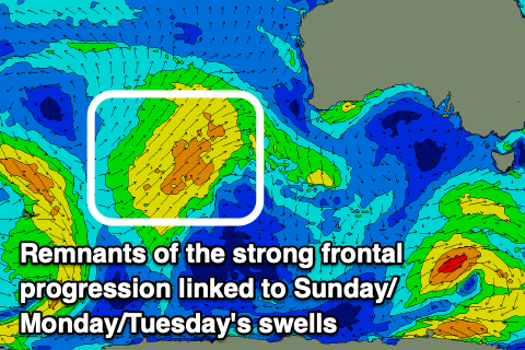
This long-range swell has been generated by a great, slow moving frontal progression through the southern Indian Ocean, with extra-large surf due from it across Western Australia later today and tomorrow morning, with it pushing on further towards us for Sunday/Monday.
Sunday morning looks to see some less consistent, W/SW foreruners with the bulk of the energy building into the late afternoon/Monday.
The exposed beaches to the east look to build from 3ft through the morning to 6ft later, holding a similar size Monday morning before easing off later.
The Surf Coast should see 3ft sets on the magnets at the peak of the swell but they’ll be very slow.
Sea breezes on Sunday only look to kick in from about mid-afternoon with Monday morning seeing less favourable, light E/SE winds to the east of Melbourne, S/SE to the west though without much strength strength, increasing a little through the day.
More variable winds are expected on Tuesday morning as the swell continues to ease, while a trough will bring an afternoon change and strong S/SW winds into Wednesday.
The end of the week looks small and onshore, while next weekend looks a little more promising as a flurry of healthy frontal systems fire up to our south-west later week. More on this Monday. Have a great weekend!

