Fun weekend of surf
Victorian Forecast by Craig Brokensha (issued Friday January 3rd)
Best Days: Tomorrow ahead of sea breezes, Sunday ahead of the shallow change, exposed beaches Wednesday morning and Thursday for the keen
Features of the Forecast (tl;dr)
- Easing mix of W/SW swell tomorrow and new SW groundswell, smaller Sun
- Small mid-period W/SW swell Sun PM, easing Mon
- Light, local offshore winds tomorrow AM, shifting NE then E ahead of sea breezes
- Light, local offshore winds Sun AM, shifting SW mid-late PM
- Strengthening SW tending S/SW winds Mon with a building windswell
- Gusty S/SW winds Tue, easing and tending SE before strengthening again
- Building SE windswell Tue, easing Wed with fresh but easing E/NE winds ahead of SE sea breezes
- Small to tiny Thu with N/NE winds
Recap
The swell kicked more in size through yesterday and conditions were bumpy and average across all locations but doable for the keen across the Surf Coast and selected spots to the east.
The afternoon saw some stronger groundswell kick in and this morning this looks to be slowly easing with waves to 4-5ft on the Surf Coast magnets, 6ft to occasionally 8ft to the east. Winds are a bit more around to the east cleaning up conditions to the east.
Winds should tend lighter E/NE across spots to the east through the morning ahead of fresh S/SE sea breezes.

Chunky, bumpy sets yesterday afternoon
This weekend and next week (Jan 4 - 10)
Tomorrow looks the pick of the period as winds swing around to the north, with light, local offshore breezes due (N/NW to the west, N/NE to the east), shifting more easterly through the afternoon ahead of sea breezes.
Swell wise, the current energy will back off in size, but a reinforcing pulse of SW groundswell due later today should maintain 3-4ft sets on the Surf Coast magnets for the dawny before easing through the day. 6ft sets are due to the east before backing off through the day.

Sunday looks smaller with similar, light local offshore winds that should hold until mid-afternoon ahead of a shallow SW change.
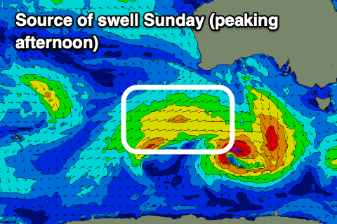
There should be a small pulse of mid-period W/SW swell energy filling in through the day, generated by a trailing front spawning off the back of small low forming late in our swell window.
This doesn’t look to really top 2ft+ on the Surf Coast but should provide fun 4ft+ sets to the east into the afternoon with the favourable winds.
Make the most of these windows as a deepening trough moving through Monday will bring strong SW tending S/SW winds while also kicking up some poor, localised windswell. There’s the chance the trough could stall a little bringing light W/NW winds early to the Surf Coast but it will be small and not worth worrying about.
Into Tuesday the trough is due to move north-east resulting in strong S/SW winds easing temporarily before shifting SE and strengthening again, producing building levels of junky SE windswell.
A further improvement in winds is likely Wednesday as high pressure moving in from the west slides the trough further north, resulting in fresh but easing E/NE winds through the morning before sea breezes kick back in.
Swell wise, the SE windswell will be easing back from 2-3ft on the Surf Coast with some inconsistent background energy likely to maintain 2-3ft sets on the exposed beaches to the east.
The high will block any major swell generating systems from firing up within our medium to close-range swell windows. This will see Thursday coming in smaller and fresh N/NE winds will favour exposed breaks but don’t expect much over 2ft.
Longer term the outlook remains slow but more on this Monday. Have a great weekend!


Comments
2025 starts off with a heatwave and the state at the beach, RIP to those lost, happiness for those saved.
https://www.9news.com.au/national/victoria-heatwave-man-dies-several-res...
Watch till the end - the photobombing bar is set very high early on in the new year! Legends.
hahaha.
haha, very high indeed.
Classic. Didn’t see that coming.
Haha, multiculturalism at its finest. So good :-0
Haha.