Fun beachy options tomorrow, with small west swells to follow

Victorian Forecast by Craig Brokensha (issued Wednesday December 25th)
Best Days: This morning, tomorrow morning exposed beaches, Saturday and Sunday mornings Surf Coast
Features of the Forecast (tl;dr)
- Small background W/SW swell tomorrow with strong N/NE winds, shifting N/NW into the PM ahead of an evening SW change
- Building W/SW swell Fri with gusty W/NW winds, shifting W/SW-SW into the PM
- Reinforcing W/SW swell Sat and Sun with NW tending W/NW winds ahead of a SW change Sat, W/NW Sun ahead of a strong S/SW change mid-late PM
- Smaller Mon with variable winds ahead of SE sea breezes
- Moderate sized, mid-period W/SW swell building Tue, peaking Wed with S/SW winds Tue, S Wed
- Swell holding Thu with S/SE winds
- Slightly stronger W/SW swell next Fri
Recap
Merry Christmas!
Yesterday morning provided some better size and decent conditions across the Surf Coast with a lumpy 3-4ft of swell under light winds while locations to the east were still onshore and solid.
This morning the swell is down and conditions are lumpy thanks to overnight onshore breezes, but we’ll see conditions improving across all locations through the day ahead of afternoon sea breezes.
This week and weekend (Dec 26 - 29)
Tomorrow is looking the pick for the beaches with a strengthening, hot N/NE breeze that will start to shift N/NW mid-afternoon ahead of a cool, strong S/SW change into the evening.
Swell wise, the current energy will continue to ease, but some background energy should provide 3ft to possibly 4ft waves to the east with small 1-2ft leftovers across the Surf Coast.
On Monday, Friday’s swell potential was downgraded thanks to the incoming frontal system tomorrow being weak and fast tracking, but it now looks like we should see 2ft to occasionally 3ft waves building on the Surf Coast magnets during the day (biggest afternoon), generated by a strong burst of W/SW winds as it moves across us tomorrow evening.
Winds will favour the Surf Coast and be gusty out of the W/NW, shifting W/SW-SW into the afternoon, with Saturday likely to come in around a similar size thanks to a secondary trailing front moving through Friday. Conditions will be nice and clean on the Surf Coast again under a gusty NW tending W/NW breeze ahead of a mid-late afternoon SW change.
Into Sunday, a less consistent but fun sized mid-period W/SW swell should maintain 2ft to occasionally 3ft waves on the Surf Coast, with a drop in energy on Monday back to the 2ft range with 4ft sets to the east.
Winds on Sunday will continue to favour the Surf Coast and be offshore from the W/NW through the morning, shifting strong S/SW into the mid-afternoon.
On Monday, winds are due to back right off and tend variable creating improving conditions to the east, but there’ll likely be lots of leftover lump and imperfection. Late morning to early afternoon will be best ahead of sea breezes.
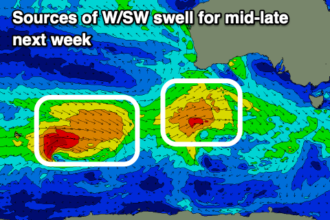
From Tuesday onwards we’re looking at a decent run of W/SW swell energy, moderate in size initially but then possibly a little larger late week. This will be thanks to back to back frontal systems moving in from the south-west of Western Australia, under the country next week.
The first is forecast to generate a healthy fetch of strong W/SW winds, followed by a stronger system with persistent gales due to be projected through our swell window.
The first system should produce a moderate sized W/SW swell for Wednesday, followed by a slightly stronger pulse on Friday.
Unfortunately it looks like high pressure will move in following a S/SW change on Tuesday which will bring unfavorable S/SE winds Wednesday/Thursday, possibly swinging offshore next Friday. We’ll have a closer look at this Friday.