Good waves on the beaches to end the week

Victorian Forecast by Craig Brokensha (issued Wednesday December 18th)
Best Days: Exposed beaches from mid-late morning tomorrow, Friday exposed beaches ahead of the change, Surf Coast for the keen Sunday and Monday mornings, exposed beaches next Thursday
Features of the Forecast (tl;dr)
- Slowly easing W/SW swell tomorrow with improving conditions as winds tend E/NE during the AM, then variable ahead of freshening sea breezes
- Easing swell Fri with moderate E/NE-NE winds ahead of a strong SW change mid-PM
- Strong SW-S/SW winds Sat with a building W/SW swell
- Peak in mid-period W/SW swell Sun with fresh W/SW-SW winds (lighter and more W for a period early on the Surf Coast)
- Localised SW swell Mon/Tue with strong W/SW winds tending SW winds Mon (lighter and more W for a period early on the Surf Coast), strong SW-S/SW winds Tue
- Easing swell Wed with S/SW tending S/SE winds
- Smaller Thu with NE winds
- Moderate sized W/SW groundswell Fri with strong SW winds
Recap
Yesterday was a lay day as the swell bottomed out under morning W/NW winds, strengthening from the W/SW through the day while kicking up a weak windswell.
Today we’ve got our stronger W/SW groundswell on the build but with poor conditions thanks to a gusty southerly wind. The Surf Coast is 3ft+ with 5ft waves to the east and we should see the swell reaching more to 4ft and 6ft to occasionally 8ft to the east through the day as winds shift S/SE.
This week and weekend (Dec 19 - 22)
Looking at the Cape Sorell wave buoy we can expect a peak in the current, building W/SW groundswell through this afternoon with a slow drop through tomorrow, down from 3ft+ on the Surf Coast during the morning with chunky 5-6ft sets to the east.
Local winds and conditions will be average at dawn but improve during the morning as pre-dawn E/SE winds shift E/NE during the morning and then tend variable later morning. The afternoon will then see freshening sea breezes so get in before mid-afternoon.
Friday also looks the goods but smaller with a moderate E/NE-NE wind that will be hold mid-afternoon before a strong SW change moves through.
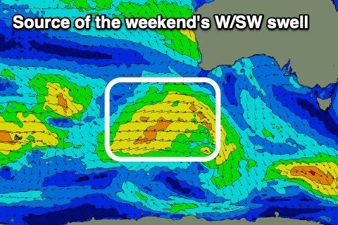
The trough linked to Friday’s change will leave strong SW-S/SW winds into Saturday that look to ease a touch into Sunday but likely remain moderate to fresh from the SW. The Surf Coast should see weaker W’ly winds at dawn on Sunday under this scenario and swell wise, a new W/SW swell is expected to be in the water.
This is being generated by a relatively weak but healthy Southern Ocean frontal progression moving in from the South West of Western Australia, under the country on Thursday/Friday.
The Surf Coast looks to come in around 2-3ft with 4-5ft+ sets to the east while a secondary front pushing through Monday will likely produce a bit more size but with lower quality and strong SW winds (weaker and more W’ly early Surf Coast).
Continued weak frontal activity looks to continue through Tuesday and Wednesday, directing persistent SW-S winds into the region while also producing moderate levels of weak SW swell.
We’ll hopefully see winds revert back to the NE on Thursday as the swell starts to ease, opening up the beaches for some quality surf.
Unfortunately another SW change is likely Friday along with a better quality W/SW swell due, but we’ll have a closer look at this on Friday.