Hit the beaches over the coming days
Victorian Forecast by Craig Brokensha (issued Monday December 2nd)
Best Days: Today, tomorrow morning, Thursday morning to the east, Friday morning (early to the east)
Features of the Forecast (tl;dr)
- Small-mod sized, inconsistent W/SW swell building today as winds hold from the E/NE-NE
- Easing swell tomorrow with fresh-strong N/NE winds, tending N/NW lae AM then SW into the early PM
- Small-mod sized, inconsistent W/SW groundswell for Wed, peaking in the PM with variable S-S/SE winds, freshening from the SE
- Slight drop in size Thu with E/NE-NE tending SE winds
- Smaller Fri with fresh N/NE-N/NW tending SW winds
- Low point in swell Sat with variable tending SE winds
- Small W/SW swell Sun with strong SW winds
- New mid-period SW swell Mon with weak S/SE-SE winds, freshening
Recap
The Mornington Peninsula cleaned up nicely into Saturday morning with a chunky mix of easing SE windswell and SW groundswell while Phillip Island was a little more wind affected, poor on the Surf Coast.
Yesterday offered cleaner waves to the west as winds swung more northerly and then north-west through the day with a smaller but fun mix of SE and SW swells. Locations to the east were best early before deteriorating as winds swung more west of north.
Today the surf is small and conditions are clean across most spots, but a new W/SW swell is due into the afternoon, though its source was very distant so it’ll be very inconsistent.
Sets to 2-3ft are due to develop on the Surf Coast magnets with 4-5ft waves to the east as winds remain mostly favourable for spots east of Melbourne.
This week and weekend (Dec 3 - 8)
Today’s long-range W/SW groundswell is due to ease into tomorrow under fresh to strong N/NE winds, favouring the exposed beaches to the east ahead of a shift to the N/NW late morning and then strong SW change early afternoon.
The trough linked to the change looks relatively weak with winds due to go variable into Wednesday morning out of the S-S/SE. It won’t be perfect and winds will freshen through the day out of the SE.
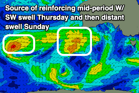
This will be as our new, inconsistent W/SW swell arrives, followed by a secondary pulse on Thursday.

The low linked to this swell moved slowly through our western swell window on the weekend, to the south-west of Western Australia.
Fetches of gales should produce an inconsistent groundswell that’s due to build through Wednesday to 3ft on the Surf Coast magnets with 5-6ft sets to the east but with that increasing wind.
Thursday will likely come in more around 2-3ft on the Surf Coast and 4-5ft+ with a bit of lower period W’ly energy and winds look to shift E/NE-NE creating great conditions on the beaches before sea breezes kick in.
Friday will be smaller again and winds will quickly swing from the N/NE to N/NW ahead of a weak trough and SW change.
At this stage a low point in swell is expected on Saturday with variable morning winds, while a new mid-period W/SW swell is due into Sunday but with no major size. Strong SW winds look to spoil this swell on Sunday with weaker onshore breezes into Monday.
Some better mid-period SW swell from a stream of weak but healthy frontal activity is due on Monday, but we’ll look at this in more detail on Wednesday.
In the meantime the beaches look great for a surf.


Comments
Sea breeze killed it Craig.
I've seen, watch later it should go back offshore.
Have been a fair few of those days lately where the initial sea breeze comes in hard and it looks completely blown out, everyone gets out of the water then 45 mins later its settled and half decent again with no one left out. Can be worth the gamble if you value low crowds more than perfect offshores.
Similar thing often happens in Winter when the squally strong west wind and rain comes through heavy for 10-20 mins, then wind tapers off leaving half the crowd as before.
keep that one to yourself Ron
classic weasly