Varying swells and winds thanks to lingering troughiness
Victorian Forecast by Craig Brokensha (issued Monday November 25th)
Best Days: Wednesday morning, Friday ahead of sea breezes, Saturday morning selected spots
Features of the Forecast (tl;dr)
- Small-moderate sized W/SW swell building Tue PM with light-moderate S/SE tending SE winds, freshening through the day
- Easing surf Wed with fresh N/NE winds (N-N/NW to the west), tending W/NW-NW early PM ahead of a S change
- Weak S/SE winds Thu AM with smaller surf
- Moderate sized, inconsistent W/SW groundswell building Fri PM, easing Sat
- E/NE-NE tending fresh SE winds Fri, variable tending W/SW then strong SW Sat
- Small surf with W/NW tending SW winds Sun
Recap
Our reinforcing pulse of S/SW swell expected on Saturday didn’t offer much in the way of size with slow 2ft+ sets across the Surf Coast, bigger and better to the east ahead of sea breezes.
Yesterday variable winds created fairly clean fun conditions to the east again with small 1-2ft leftovers on the Surf Coast.
Today, onshore winds from the get go along with a low point in swell are creating poor conditions.
This week and weekend (Nov 26 - Dec 1)
Looking at tomorrow and we’ve got our good pulse of W/SW swell due to fill in through the day, generated by a healthy front moving in from the South West of WA, under the country on the weekend.
There’s no change to the expected peak in size with building sets to 2-3ft due on the Surf Coast after lunch, 4-5ft+ to the east but overnight onshore winds will tend more light-moderate S/SE at dawn to SE through the morning and then freshen into the afternoon.

Wednesday will be better as the swell starts to back off with a fresh N/NE’ly to the east N-N/NW to the west, shifting N/NW-W/NW across all locations early afternoon ahead of a S’ly change thanks to a weak trough moving through.
The weak nature of the trough will see winds back off into Thursday but again linger out of the S/SE, with Friday seeing a shift in winds back to the E/NE-NE through the morning.
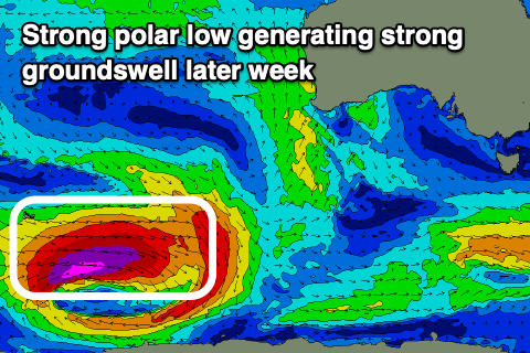
This will be along with the arrival and building of a strong new SW groundswell, generated by a polar low currently around the Heard Island region. This low is generating storm-force winds while projecting east and should kick up moderate levels of surf into Friday afternoon.
The Surf Coast is on track to reach 4ft into the afternoon with 6ft+ sets to the east though with developing sea breezes. There should be a fun window with the building swell ahead of sea breezes.
The swell will start easing through Saturday but winds are still a little tricky thanks to a trough come low lingering in the region with variable tending W/SW breezes likely before freshening from the SW during the day, W/NW tending SW on Sunday.
No swell is due into Sunday from the low at this stage with varying winds and smallish surf due into early next week. More on this Wednesday.

