Fun on the beaches tomorrow, tricky next week
Victorian Forecast by Craig Brokensha (issued Friday October 25th)
Best Days: Exposed beaches tomorrow morning and late morning Sunday ahead of the change, Wednesday and Thursday mornings Surf Coast
Features of the Forecast (tl;dr)
- Weak, easing SW swell tomorrow with N/NE-NE winds ahead of gusty E/SE-SE sea breezes
- Smaller Sun AM, ahead of a small, building W/SW swell into the PM
- N/NE winds to the east and N/NW to the west Sun AM, shifting strong S/SW into the PM
- Moderate sized SW swell building Mon with dawn W/NW tending strong SW winds
- Easing swell Tue with fresh to strong SW winds
- Moderate sized W/SW groundswell Wed with W/NW tending strong SW winds
- Easing surf Thu with W/NW tending fresh SW winds
- Smaller Fri with S/SW winds
Recap
The expected pulse of S/SW groundswell on Wednesday did fill in during the day, with it arriving a little later than expected but kicking strongly through the late morning. The Surf Coast saw 3-4ft sets with 5-6ft waves to the east with workable onshore winds.
This swell eased into yesterday morning but some close-range W/SW energy front a frontal system moving through provided a bit more size than anticipated. The Surf Coast continued around 3-4ft with fairly clean conditions across protected spots, bigger and onshore to the east.
Today the swell is similar but a bit weaker and with less ideal winds which have just detiorated further.
This weekend and next week (Oct 25 - Nov 1)
The current swell energy is expected to ease into the weekend and winds will swing around to the NE-N/NE tomorrow morning creating much cleaner conditions across the beaches.
Size wise, the early is unlikely to be too chunky to the east, especially with the help of the morning high tide, with easing sets from 4ft+ likely, with 2ft+ waves on the Surf Coast.
Sea breezes will develop into the afternoon before winds shift back more E’ly on dark.
Sunday morning then looks smaller with N/NE winds to the east, N/NW to the west, giving into an afternoon S/SW change as a trough moves through.
At the same time as the trough starts moving through though, some new mid-period W/SW swell should be on the build with the beaches being the pick in regards to nailing a window with the building swell ahead of the change.
This swell will be smallish, generated to the south-west of Western Australia but should increase the Surf Coast back to the 2ft range with 4ft+ sets to the ease into the afternoon/evening but with the onshore winds.
The moderate sized increase in W/SW-SW swell energy due Monday afternoon/Tuesday is still on track and so are the average wind and poor conditions.
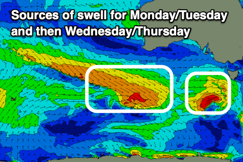
The source of swell will be a couple of healthy fronts moving in under the country through the weekend, with the first forming a small low pressure system to our south-west on Sunday.
This should produce a kick in mid-period SW swell Monday afternoon to 3ft+ on the Surf Coast and 4-6ft to the east, easing back Tuesday morning from a similar size.

Unfortunately a stubborn high pressure system will set up inside the Bight following the progression of this low, with additional weaker fronts skirting the southern flank, bringing persistent, strong winds out of the south-west for our region.
Early Monday ahead of the swell may see a brief period of dawn W/NW winds but otherwise strong from the SW, with Tuesday seeing fresh to strong SW-S/SW winds all day.
Wednesday morning looks a little better as winds ease and tend back W/NW through the morning, and swell wise we’re looking at moderate levels of inconsistent W/SW groundswell energy from a trailing front generating a great fetch of W/NW gales south of WA on Sunday.
The Surf Coast should come in around the 3ft+ range with 5-6ft sets to the east and winds will revert back to the S/SW-SW through the late morning.
Thursday morning looks clean again on the Surf Coast but with easing levels of swell from Wednesday.
Longer term, the outlook is a bit wishy washy so check back here on Monday for the latest. Have a great weekend!


Comments
"Unfortunately a stubborn high pressure system will set up inside the Bight"
And it begins...
Is the daily surf report from PI being done by AI now.... 7 out of 10 today?? where ?? there was a bit of swell 2-3, but no banks..
Fun on the ninch this morning. Size and conditions pretty much spot on as reported. Never bother reading the ratings.
Disagree and feel free to watch the Wooly surfcam replays, pretty bloody average