Fun weekend, poor next week
Victorian Forecast by Craig Brokensha (issued Wednesday October 23rd)
Best Days: Keen surfers Friday, beaches Saturday morning, keen surfers Tuesday and Wednesday mornings
Features of the Forecast (tl;dr)
- Small-mod sized mid-period W/SW swell tomorrow with moderate W/NW tending strong SW winds late AM
- Slightly bigger, reinforcing SW swell Fri with fresh SW-S/SW winds (possibly weak W early Surf Coast)
- Easing swell Sat with E/NE-NE tending fresh SE winds
- Temp low point in swell dawn Sun, with a small, building W/SW swell through the day
- N/NE-NE winds, tending strong S/SW into the PM
- Moderate sized mid-period SW swell building Mon with strong SW-S/SW winds (possibly weak W early Surf Coast)
- Easing swell Tue with gusty S-S/SE winds
- New moderate sized groundswell Wed with S/SE winds
- Easing surf Thu/Fri with gusty S winds
Recap
Yesterday was another cracker across the beaches with clean conditions most of the day (though some spots didn’t enjoy the touch of north in the wind as much) and with plenty of swell in the 4ft+ range. The Surf Coast saw 2ft surf mostly, with bigger sets around Barwon Heads.
This morning a shallow onshore change has impacted the beaches to the east while the Surf Coast is cleaner but lumpy and small. An expected pulse of S/SW groundswell from a strong low that formed south-west of us looks to have not really made an impact.
This week and weekend (Oct 24 - 27)
The end of the week looks generally weak swell wise, with a pair of approaching frontal systems due to kick up some mid-period W/SW swell tomorrow, followed by SW energy on Friday.
Tomorrow’s W/SW swell is being generated by a fetch of relatively weak W/SW winds moving in from the west today and tonight. 2-3ft sets due on the Surf Coast with 4-5ft waves to the east, with Friday’s swell coming in more to 3ft+ on the Surf Coast (easing through the day).
Local winds will be moderate out of the W/NW tomorrow morning, favouring the Surf Coast, shifting SW later morning and becoming fresh to strong.
Friday then looks dicey as a high moves in behind the secondary swell generating front, bringing gusty SW tending S/SW winds that might be light W’ly for a short period early on the Surf Coast. Regardless there’ll be lots of lump in the mix.

The weekend is still looking good for the beaches as the high moves east across us, swinging winds around to the E/NE-NE through Saturday morning along with easing levels of swell from 2ft on the Surf Coast and the 3-4 range.
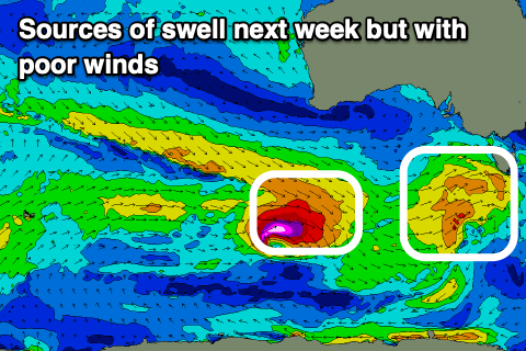
Sunday looks initially smaller ahead of some new mid-period W/SW swell filling in through the day. This and additional size into early next week will be generated by a stream of healthy but not overly impressive frontal systems moving in under the country later this week and though the weekend.
Sunday’s swell should build to 4ft+ through the day on the Mornington Peninsula, with 2ft sets to the east, but a N/NE-NE offshore in the morning will shift to the S/SW into the afternoon and strengthen as one of the better swell generating systems moves up and into the state.
A moderate sized SW swell is due from this front on Monday (peaking afternoon) but with strong SW-S/SW winds, with only a very slim chance of early W winds on the Surf Coast.
Winds look to remain fresh from the S-S/SE on Tuesday as the swell eases thanks to high pressure following the front, weaker and still lingering from the S/SE on Wednesday.
Size wise, some new SW groundswell is due on Wednesday thanks to a strong but south-east tracking low following the front moving through Sunday/Monday, though no improvement in winds or conditions are expected at all. Quite the opposite as winds strengthen again out of the S/SW-S thanks to low forming in the Tasman Sea.
So with this in mind, the weekend is worth targeting for a surf, as is tomorrow morning on the Surf Coast.


Comments
Your expected pulse of S/SW groundswell hit about midday today Craig. Swell has muscled up to 5’-6’ on eastern beaches now. Good, strong lines.
Just seen, looks a good 3ft+ on the Surf Coast as well. Cheers!
Keep up the good work Craigos! Crystal's will pull up in the wool from the AGs this December and will be very impressed with these spring forerunners.
Bank central up on the corner Collins & Bourke at the moment. Peaks everywhere! Yewww