Hit the exposed beaches
Victorian Forecast by Craig Brokensha (issued Wednesday October 16th)
Best Days: This afternoon exposed beaches, tomorrow exposed beaches, early Friday exposed beaches, Tuesday morning next week
Features of the Forecast (tl;dr)
- Small to moderate sized, inconsistent W/SW groundswell building slowly today, peaking tomorrow, easing slowly Fri
- Mod-fresh NE winds tomorrow, strong N/NE tending N/NW Fri AM, then W/NW-W into the PM
- Strong SW winds Sat with a localised SW windswell, easing Sun with SW-S/SW winds
- Smaller Mon AM ahead of a new pulse of W/SW swell into the PM, easing Tue
- Light E/SE tending S winds Mon, local offshore Tue ahead of a shallow S/SW change
Recap
We saw a solid mix of S/SW groundswell and SE windswell yesterday with junky 4ft waves on the Surf Coast, 4-6ft to the east, improving during the day as the swell started to settle and winds tended a little more north of east.
This morning both swells have dropped right away with peaky 2ft leftovers on the Surf Coast, and slow 2ft waves to the east. Some new, inconsistent W/SW groundswell is due into this afternoon as winds remain favourable for the beaches to keep an eye on the cameras for an afternoon paddle.
This week and next (Oct 17 - 25)
Now that the close-range swells have come and gone, we look at a very inconsistent, long-period W/SW groundswell due into this afternoon and tomorrow across the region, generated by a significant low that moved through the Southern Ocean late last week and through the weekend.

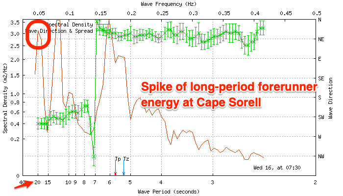
The long-period forerunners are expected to show today, and Cape Sorell is already seeing this energy (spike at 20s), with the bulk of the swell due to peak tomorrow.
There’ll be very long waits between sets and a wide range of sizes but as a ballpark estimate the Surf Coast should come in at 2-3ft with the rare bigger one likely at times, similar to the east and generally 4-5ft with possibly the odd sneaker.
Winds look great for the beaches and moderate to fresh from the NE, holding into the afternoon, with Friday seeing strong, early N/NE winds, tending N/NW late morning and then W/NW-W into the afternoon. With this the morning will be best across both regions Friday as the swell starts to ease.
This shift in winds will be linked to a deepening low moving in from the west, with it due to bring a strong SW change on Saturday and weak, localised windswell.
The Surf Coast looks to reach 3ft or so, bigger to the east before easing Sunday as winds linger out of the SW-S/SW. So all in all the weekend looks to be a write-off.
Looking at next week and winds will slowly improve, tending light E/SE into Monday but with only small levels of background swell energy in the morning.
The Surf Coast looks to come in at 1-2ft with stray 3ft sets to the east.

Into the afternoon and Tuesday morning, some slightly better mid-period W/SW swell is due, generated by a healthy frontal system currently moving across the Heard Island region. It’ll be inconsistent but should offer better 2ft to occasionally 3ft sets on the Surf Coast, 4ft+ to the east and with local offshore winds ahead of a shallow S/SW change through the afternoon.
Lingering S’ly winds are likely on Wednesday morning as the swell fades.
The end of the week is flukey with an approaching mid-latitude front due to bring some small swell but with a change in winds. More on this Friday.


Comments
https://www.willyweather.com.au/news/156760/storm+brings+large+hail%2c+t...
That's quite the weather change
https://www.willyweather.com.au/news/156761/wild+weather+predicted+acros...
This week has been such a good week for the beaches.
Can’t remember such a sustained run of good winds and good sized swell for the MP
Last night was unreal where I was. There was a pretty epic week in mid August on the beaches too
Just been looking at some videos from a mate on MP today. Looks so good.
Very nice!