Windows opening up for the beaches
Victorian Forecast by Craig Brokensha (issued Friday September 27th)
Best Days: Today, tomorrow exposed breaks, Monday morning Surf Coast for the keen, Thursday/Friday next week
Features of the Forecast (tl;dr)
- Easing S/SW swell tomorrow with freshening N-N/NE winds, stronger late
- Small Sun with strong N-N/NW tending W then SW-S/SW winds later
- Small-mod sized W/SW swell Mon AM with NW winds ahead of sea breezes
- Small Tue AM, with building SW swell into the PM but with W/NW tending SW winds late AM
- Moderate + sized SW swell Wed with light-mod SE winds, freshening
- Easing swell Thu with E/NE tending SE winds, smaller Fri with NE winds in the AM
Recap
Yesterday was poor across all locations with strong onshore winds and a mix of localised windsswell and S/SW groundswell from later Wednesday.
Today, a fun sized mid-period S/SW swell is in the mix with conditions slowly improving under a variable offshore breeze. The Surf Coast is a lumpy 3ft+ with sizey 5ft sets to the east. Conditions will continue to clean up ahead of sea breezes.
This weekend and next week (Sep 28 - Oct 4)
Tomorrow is the pick of the weekend with the current swell due to ease back from 2ft+ across the Surf Coast and 3-4ft to the east under a freshening and then strengthening N-N/NE breeze which will favour the exposed beaches.
Sunday looks smaller and windier thanks to a pre-frontal, strong N-N/NW breeze that looks to shift W’ly into the afternoon and then S/SW-SW later.

The frontal system linked to this change is still expected to produce a small pulse of mid-period W/SW swell Monday morning but only to 2-3ft or so on the Surf Coast, 4-5ft to the east. Winds should swing back to the NW Monday morning, shifting W/NW and then weak sea breezes.
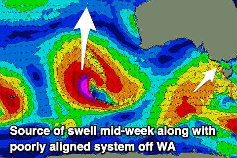
We then look at the stronger frontal progression moving in behind Sunday’s system. This looks to be a much better swell producer with a fetch of strong to gale-force W/SW winds expected to project under the country, through our south-western swell window from Monday through Tuesday.
A moderate + sized mid-period swell is due, building Tuesday afternoon but with a peak in energy on Wednesday.
Unfortunately due to it being a single system followed by high pressure, winds will go onshore when the swell kicks with a W/NW tending SW breeze late morning Tuesday and then quickly relaxing, weak SE winds into Wednesday morning.
Thursday looks to see improving surf as winds shift back to the E/NE along with easing levels of swell.
Size wise, a peak to 4-5ft+ is due on the Surf Coast Wednesday, 6-8ft to the east, easing Thursday from 3-4ft and 5-6ft respectively.
Friday looks generally smaller and with a morning NE wind, favouring the exposed beaches.
Longer term the outlook is tricky with divergent model guidance regarding instability moving in from the Indian Ocean. More on this Monday. Have a great weekend!


Comments
Meh
This outlook is not exciting like the surf at W.P. was on Monday 23-9-24.
was it you on the left inside Somers creek Mr Tee?