Smaller but fun surf from Friday
Victorian Forecast by Craig Brokensha (issued Wednesday September 25th)
Best Days: Friday morning to the east, Saturday exposed beaches, Monday morning for the keen Surf Coast, Wednesday morning and Thursday morning
Features of the Forecast (tl;dr)
- Moderate + sized spike of S/SW swell this afternoon, easing rapidly tomorrow with strong S-S/SE winds
- Small-mod sized mid-period S/SW swell for Fri AM, easing during the day with variable winds (tending N/NE to the east) ahead of sea breezes
- Easing surf Sat with freshening N/NE winds
- Smaller Sun with strong N tending NW winds
- Late increase in mid-period W/SW swell Sun, peaking Mon AM with NW winds
- Moderate + sized W/SW groundswell building later Tue, peaking Wed with variable tending SE winds
- Easing swell Thu with local offshore winds ahead of sea breezes
Recap
Following Monday’s epic day of waves, yesterday morning continued to pump with clean conditions across all locations as a large, reinforcing W/SW groundswell continued to provide 6-8ft surf on the Surf Coast, 8ft or so to the east.
The swell slowly eased into the afternoon as winds went a little funky, while this morning we’ve got half the size and light winds ahead of a trough and strong S’ly change (looks like it just hit the Surf Coast).
This week and next (Sep 26 - Oct 4)
At the base of today’s trough is a strong, intense low and this has produced a spike in S/SW groundswell for later today to what looks to be 4-6ft on the Surf Coast and 6ft+ sets to the east, easing rapidly tomorrow.
The local winds will make a mess of it though, with strong S-S/SE breezes due across all locations, easing later and tending variable N/NE to the east on Friday morning.

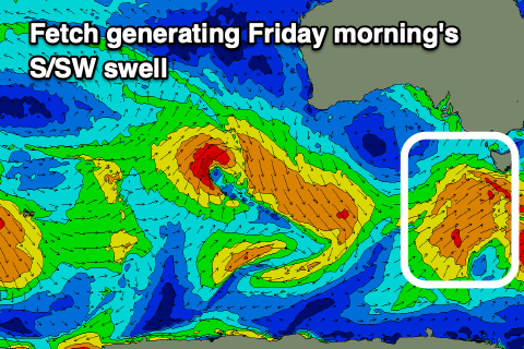
This will be along with a secondary pulse of mid-period S/SW swell, generated behind the strong, tight low, with a healthy fetch of strong S/SW winds due to be projected towards us today.
Fun 3ft+ sets are due on the Surf Coast with 4-5ft waves to the east in the morning, easing into the afternoon as S/SE-SE sea breezes kick in.
Saturday looks clean all day across the beaches with a freshening N/NE breeze but smaller, fading swell from 2ft+ on the Surf Coast and 3-4ft to the east.
Sunday will start small under strong N winds but another tight low is due to form and project a very short-lived fetch of W/SW winds towards us through the day, generating a small spike of mid-period swell for Monday morning.
The Surf Coast looks to only come in at 2-3ft, easing through the day with larger surf to the east but with a general NW flow.

Of greater significance is a stronger mid-latitude frontal progression projecting up and under the Bight from Sunday through early next week. The overall structure looks a bit disjointed but it should still produce a moderate + sized W/SW groundswell for later Tuesday but more so Wednesday morning.
At this early stage the Surf Coast looks to come in around 4-5ft with 6-8ft sets to the east though winds are a touch dicey and most likely variable Wednesday morning following a strong change Tuesday, leaving lots of leftover lump.
Thursday might be better with a more groomed offshore and easing swell but check back here on Friday for the latest.


Comments
Friday looks super fun. I reckon a mid period SSW swell could punch above its weight in shape and size. Fingers crossed.
Beacon mid morning?
Sounds fun
Yep. Could be OK. Get one of these. Trust uncle Barton.