Active period ahead, especially later next week

Victorian Forecast by Craig Brokensha (issued Friday August 23rd)
Best Days: Today, tomorrow, Sunday morning exposed beaches, Monday afternoon and Tuesday morning Surf Coast, Surf Coast Thursday onwards next week
Features of the Forecast (tl;dr)
- Easing W/SW swell this afternoon, further on the weekend
- Strong but easing N-N/NW winds tomorrow, NW into the PM
- Strengthening N/NE tending N/NW winds, easing later
- Small-mod sized, building W'ly swell Mon PM with strong but easing W/NW winds
- Easing swell Tue with strong N/NW winds
- Building W/SW swell Wed but more so Thu, large and peaking from the SW Fri with W/NW-NW winds
Recap
A small, long-range W/SW groundswell offered slow 1-2ft sets on the Surf Coast yesterday, clean across most spots, with bumpy/choppy 3-4ft waves to the east.
This morning, our much anticipated pulse of fun sized W’ly swell is in with great, clean 4ft waves on the Surf Coast and 6ft+ surf to the east.
This swell is due to start easing into the afternoon as winds vary between the N-N/NE across most locations while strengthening.

Finally some swell on the Surf Coast!
This weekend and next week (Aug 24 - 30)
We’ve got easing surf all weekend following this morning’s pulse and peak of W/SW swell.
This is thanks to the swell generating frontal system moving in under the Bight moving across past us yesterday, with a secondary weaker system moving through this morning.
Easing 2-3ft sets are due on the Surf Coast magnets tomorrow, 4-5ft to the east and then 1-2ft and 3ft to occasionally 4ft respectively Sunday.
Strong but easing N-N/NW winds are due through tomorrow, shifting NW into the afternoon, with Sunday seeing strengthening N/NE winds, shifting back N/NW into the afternoon while easing a little.
Moving into next week, and the frontal system linked to a spike in swell Monday has been downgraded a little with a small burst of strong W-W/NW winds into the early morning due to produce a very west spike in swell through the day.
The Surf Coast looks to build to 2ft to possibly 3ft on the magnets with 3-5ft sets to the east under strong but easing W/NW winds.
This swell will ease back through Tuesday from a similar size with a much more significant cold outbreak due to fire up under the country during early-mid next week.
The source will actually be the remnants of a strong low that’s spawned off Madagascar, with this due to traverse the Indian Ocean, combining with a strong frontal system projecting from the south-west of WA.
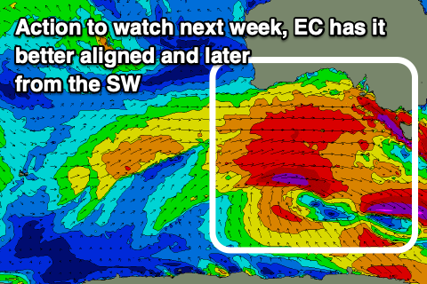
Now, the models diverge regarding the makeup of this outbreak as it moves in towards us, with GFS showing an earlier evolution of swell through Wednesday/Thursday while EC has it more delayed and into Thursday/Friday.
EC has been consistently nailing these systems in the Indian Ocean so I’m tempted to go with a large increase in W/SW and SW swells for Thursday/Friday and to what at this stage looks to be the 6ft range on the Surf Coast with winds from the north-western quadrant. More on this Monday, have a great weekend!
Comments
Cheers Craig, finally the winter we didnt really have. And just in time before the usual 3 months of SE flow. Enjoy all.