Beaches early week then reefs late week
Victorian Forecast by Craig Brokensha (issued Monday August 19th)
Best Days: Exposed beaches today and tomorrow, Surf Coast Friday, exposed beaches on the weekend (Saturday morning Surf Coast)
Features of the Forecast (tl;dr)
- Easing, inconsistent W/SW groundswell tomorrow with strengthening N/NE winds
- Tiny Wed with NW winds
- Small, inconsistent W/SW groundswell Thu with NW tending W/NW winds
- Moderate + sized pulse of W/SW swell Fri AM, easing later and through the weekend
- NW tending W/NW winds Fri, S/SW-S/SE into the mid-late PM
- Strengthening N/NE winds Sat, holding Sun
Recap
Saturday was a lay day as the swell bottomed out and a trough/low brought an onshore change through the day. This system cleared off to the east quickly yesterday allowing winds to swing around to the east along with some new short-range S’ly swell that came it at a peaky 3ft to occasionally 4ft on the exposed beaches to the east.
Today we’ve got our, inconsistent W/SW groundswell with a touch more size and power to the east as winds from the eastern quadrant create clean conditions. On the Surf Coast it’s a slow, lumpy 2ft or so.
This week and weekend (Aug 20 - 25)
We’ve got a slow couple of days ahead, but that’s mostly for the Surf Coast, as the exposed beaches to the east should continue to provide the best waves.
Today’s inconsistent, long-range W/SW groundswell is due to ease slowly through tomorrow but with developing, strong N/NE winds. This will keep locations to the east clean but make it a little tricky with easing 3-4ft sets, small to tiny on the Surf Coast.
Come Wednesday the swell looks to reach a low point and a shift in winds to the NW will favour the Surf Coast but with no surf.
On Thursday our secondary pulse of very inconsistent, long-range swell is due (generated over near South Africa) and seeing how today’s has performed on the Surf Coast, this next pulse looks to come in slower and smaller. With this I wouldn’t expect much over 1-2ft on the Surf Coast with 4ft sets to the east but with NW tending W/NW winds.

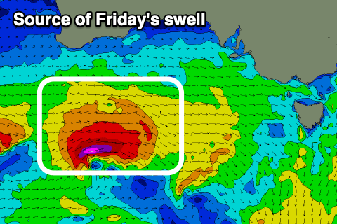
Of more interest is a strengthening mid-latitude low moving in from the west this week, with a good but tight fetch of W’ly gales (with bursts of embedded severe-gales) due to generate a fun spike in swell for Friday.
It’ll be a short-lived spike but we should see the Surf Coast magnets kicking to 3-5ft on Friday morning, easing a little into the afternoon with 6ft+ surf to the east and with NW tending W/NW winds ahead of S/SW tending S/SE winds mid-late afternoon.
This looks to be a good morning and early afternoon of waves before the winds change.
The swell will back off further into the weekend as strong N/NE winds kick in ahead of a deepening trough, persisting Sunday ahead of a W/NW to W/SW change next Monday.
The size for the exposed beaches might still be a little too much early Saturday, though becoming much more manageable through the day, with Sunday becoming smaller.
Looking at next week, and early in the piece the surf looks small but increasing winds and swell are due mid-late week and beyond as all the activity from the Indian Ocean finally starts moving further east towards us. More on this Wednesday.


Comments
what? 3-5ft? on the surlfess coast?
Whip out the 9’6 PLStocks, winter is here
Pretty impressive buoy data and what it’s actually translating to on the beaches.