Poor weekend, fun on the exposed beaches early next week

Victorian Forecast by Craig Brokensha (issued Friday August 16th)
Best Days: Exposed beaches today, exposed beaches Monday and Tuesday, Surf Coast next Friday
Features of the Forecast (tl;dr)
- Fading tiny surf tomorrow with N/NW tending W/NW and then SW winds (freshening later)
- Weak S swell Sun with gusty E/SE tending SE winds
- Inconsistent small-moderate sized W/SW groundswell for later Sun, peaking Mon with E/NE-NE winds, freshening into the PM from the NE
- Easing surf Tue with strong N/NE winds
- Inconsistent small W/SW groundswell Thu with strong W/NW tending W/SW winds
- Building mid-period W/SW swell Thu, peaking Fri with W/NW tending variable winds
- Easing swell next weekend with NE winds Sat
Recap
Generally good to great conditions across the exposed beaches yesterday with small levels of W/SW swell to 2ft on the Surf Coast and 4ft on the sets to the east.
This morning looks similar with the exposed beaches being the pick as the swell eases during the day.
This weekend and next week (Aug 17 - 23)
The weekend ahead looks poor with the current swell due to ease further as winds shift from N/NW to W/NW during the morning tomorrow ahead of a shallow S/SW change early afternoon, freshening into the afternoon.
The Surf Coast which will be cleanest looks to be 1ft or so, smaller and lumpy/bumpy to the east.
The incoming mid-latitude low that was expected to generate some weak S’ly windswell Sunday now looks more east to west angled bringing no real decent S’ly energy along with cross-shore, fresh E/SE tending SE winds.
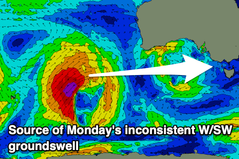
Moving into Monday and our good, new but inconsistent W/SW groundswell looks on track, as do the favourable winds for the exposed beaches. The low linked to this swell has moved through the Indian Ocean and is now projecting towards Indonesia while weakening.
It should offer inconsistent but good 2-3ft sets on the Surf Coast magnets with 4-5ft+ surf to the east as winds shift a little more E/NE-NE during the morning and persisting from the NE while freshening through the afternoon.
The swell will then ease on Tuesday as strengthening N/NE winds create tricky conditions but still favour exposed breaks.
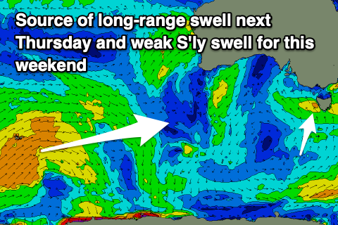
Another very long-range W/SW groundswell is then due next Thursday, with the source being a significant storm south of South Africa. This storm has weakened while pushing east and it’s only due to come in at a very inconsistent 2ft on the Surf Coast and 3-4ft to the east as winds shift strong W/NW to W/SW.
The shift in winds will be associated with a healthy mid-latitude frontal system moving in from the west and with this a moderate sized mid-period swell is due later in the day but more so Friday to the 3ft range on the Surf Coast, 4-6ft to the east as W/NW-NW winds favour the former.
Next weekend looks to see easing surf with cleaner conditions for the more exposed breaks, but more on this Monday along with likely better swell potential later the following week. Have a great weekend!
Comments
Who wants to buy my house on the Surfcoast.
I’ve had Enough of this crap.
"Surfcoast" - the word has become an oxymoron.
Might start a petition to rename the MP to the surf coast, it’s pumped all week lol
Did a drive up and down the coast today while the little one was having a nap and by golly, the stark contrast between Rye/Sainters and Porto is at peak unbelievable. It’s amazing how different they can be yet so close as the crow flies.
You mean the difference in the bank/gutter formations?
Flag the weekend for a surf ? , oh . I get it ….. red flag sadly.
Yes, it's been frustratingly small and inconsistent on the SC this week, especially compared to MP and the PI, but I've had four sessions of fun small clean peeling waves with only a few people out. The conditions have been flawless with sun and offshores. Considering how crap it's been for a lot of this year I'll take it.