A fun week across the exposed beaches
Victorian Forecast by Craig Brokensha (issued Monday August 12th)
Best Days: Exposed beaches very day this week
Features of the Forecast (tl;dr)
- Small, inconsistent W'ly groundswell building tomorrow PM, easing slowly Wed
- Strong N-N/NE winds tomorrow, easing and tending N/NW on the Surf Coast into the PM, N/NE to the east
- Small-mod sized, inconsistent W'ly swell for Wed PM, easing Thu AM
- Fresh N/NE-N winds Wed AM, easing and tending N/NW on the Surf Coast into the PM, N/NE to the east
- Easing swell Fri with N/NE winds
- Tiny on the weekend with SW winds
Recap
Our better pulse of W/SW swell energy for Saturday came in nicely with 3ft+ sets on the Surf Coast magnets with clean conditions, a bit too big for the beaches and tricky to the east to 4-6ft.
Yesterday the swell was on the ease with slower 3ft sets on the Surf Coast and a little less size to the east, improving after lunch as winds tended more east of north.
This morning we’ve got clean conditions across both regions with a smaller, easing swell.

Great fun when the sets came on Saturday
This week and weekend (Aug 13 - 18)
The best west swells for the coming week have come and gone and we now rely on very inconsistent, fluky pulses out of the Indian Ocean that will be best suited to the exposed beaches across the state.
A strong and high riding frontal progression in the southern Indian Ocean is due to generate a small, inconsistent W’ly groundswell for tomorrow afternoon, building through the day and then easing Wednesday.
Slow 2ft sets max are due on the Surf Coast, 4ft to the east, but we’ve got a slightly better pulse of energy due on Wednesday afternoon and Thursday morning.
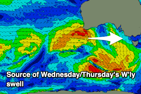
This is being produced by a trailing frontal system that’s currently moving across and under Western Australia.

A good, broad fetch of strong W’ly winds should generate a better 2ft+ of swell for the Surf Coast Wednesday afternoon, easing Thursday with 4ft+ sets to the east.
Looking at the local winds and strong N-N/NE winds are due tomorrow morning, weakening and tending more locally offshore into the afternoon, similar Wednesday but only fresh during the morning to the east.
Thursday looks favourable with moderate, local offshore winds, tending weaker NE into the afternoon.
Easing surf with N/NE winds is expected on Friday with the surf bottoming out on Saturday as a trough brings an early SW change that unfortunately looks to linger into Sunday.
Longer term there’s nothing major due at all through next week and with trickier more variable winds, os make the most of the clean, fun waves across the exposed beaches this week.


Comments
when i got out of the water this morning on the SC (small, slow, cold) I noticed i had said many times this winter "well it was better than nothing". These depressing forecasts show I'll be saying it more! Yes some fun clean small days here and there, but another average winter
On the flip side the MP was cooking all weekend long.
What a cracker yesterday afternoon on the MP. Hope it holds all week. Looks like early to bed tonight ;)
Papa Craigos what is going on with the weekend swell train analysis - looks like it juiced up today?
Judging by the wave period on the models it may just be some localised windswell, but interested in hearing Lord Craigo's view on this