West energy continues, best over the coming days

Victorian Forecast by Craig Brokensha (issued Friday August 9th)
Best Days: Tomorrow, Sunday, Monday exposed beaches, Tuesday exposed beaches, Thursday exposed beaches
Features of the Forecast (tl;dr)
- Small-mod sized, inconsistent W/SW groundswell building today
- Slightly better W/SW swell tomorrow with N/NW-NW tending variable winds (N/NE on the MP)
- Slowly easing swell Sun with N/NW tending E/NE winds to the west, N/NE to the east
- Smaller Mon with local offshore tending N/NE winds
- Small, inconsistent W/SW groundswell building later Tue, peaking Wed with strong N/NE winds Tue, W/NW tending SW Wed
- Slightly better W/SW swell Thu with N/NE winds
Recap
Wednesday’s swell eased back steadily through yesterday as strong northerly winds favoured some spots over others.
Today, our first pulse of tricky W’ly swell is on the build with clean slow 2ft waves on the Surf Coast, 3-4ft to the east.
We should see this swell reaching 2-3ft and 4-5ft+ respectively into the afternoon as winds hold from the NW but ease.
This weekend and next week (Aug 10 - 16)
The west swells continue this period, and the reason is outlined in this article: Stratospheric Warming Event Comes Home To Roost
This afternoon’s increase in W/SW swell will be followed by a better, more consistent pulse of energy tomorrow, generated by a healthy mid-latitude frontal system passing under the country yesterday and today.
A good fetch of strong W’ly winds should provide more consistent 3ft waves across the Surf Coast magnets (possible rare bigger one) with 4-6ft sets to the east.
A trailing frontal system is generating slightly stronger but less favourably aligned W/NW winds today and this should help hold the swell up around a similar size Sunday morning before easing into the afternoon, further Monday.
Looking at the local winds and N/NW-NW tending variable breeze is due tomorrow, with winds likely tending N/NE across the Mornington Peninsula into the afternoon, possibly W/NW across Phillip Island.
Sunday should see N/NW tending N/NE winds, opening up more options to the east into the afternoon, with the Surf Coast likely becoming a bit bumpy with winds tending more E/NE later.
As the swell continues to ease Monday, local offshore winds will create clean conditions.
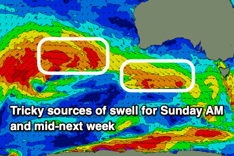
We then look at our tricky, inconsistent W/SW groundswell due later Tuesday but more so Wednesday across the region.
The source is a very poorly aligned but strong storm in the southern Indian Ocean, with fetches of gale-force winds being essentially blocked by Western Australia.
With this I’d set the expectations very low for a wave on the Surf Coast, and event further east.
An inconsistent increase to 2ft max is due on the Surf Coast, 4ft to the east and with strong N/NE winds Tuesday, W/NW tending variable Wednesday.
A trailing front pushing up and then under Western Australia on the weekend and Monday looks to generate a slightly better pulse for later Wednesday and Thursday more towards to 2ft to occasionally 3ft on the Surf Coast, 4-5ft+ to the east but we’ll review this Monday. Winds look favourable and out of the N/NE, tending back NW on Friday.
Longer term more inconsistent west swell is due but we’ll go over this in Monday’s notes. Have a great weekend!
Comments
Thanks for these offshore winds lord Craigos!
Quick question though, is Swellnet consistently over calling the size of these west swells or is that just me?
It will often say '2-3 foot' on the Surf Coast but it will be max 1-1.5 foot when I check it. Am I tripping or is anyone else feeling the same?
Thanks Cowboy. Model, or my notes?
Thanks Craig, I only rely on your notes generally. There was such a big difference in size/consistency during the week after a bit more south was in the swell, the notes were spot on for that run of waves.
I'm generally forecasting for the magnets, so when the swell is west, all other breaks are going to come in smaller and slower. Less so when there's more south in the swell.
Question Craigos (all praise to the king), what do you consider the magnets? Bells & Winki?
Fisherman's
easy mate, no exposure
Yep and 13th.
Sshh keep it to yourselves!
If the swell has a lot more west in it, 13th is often larger than even the magnets on the Surf Coast form experience.
Yep, a touch bigger again usually.
The reports have been consistently over for on these west swell for a while now.
Hey is everybody seeing the Goldcoast when they hit the "Surf Forecast" tab on this page or just me?
Spinafex - if I've been looking at other forecast pages, e.g. Qld or Indo, if at a later stage I use my "favourites" quick link back to the detailed Vicco forecast notes, it usually takes me back to the area i was last on, not the Vicco notes.
It does this on my phone as well.