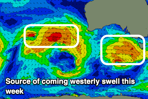
West, west west
Victorian Forecast by Craig Brokensha (issued Monday August 5th)
Best Days: Tomorrow, Wednesday, Thursday exposed beaches, Friday afternoon Surf Coast, weekend both regions
Features of the Forecast (tl;dr)
- Small-mod sized SW swell tomorrow, easing later with NW winds
- New W/SW swell Wed with mod-fresh N/NW tending weaker N winds
- Easing swell Thu with strong N/NE winds
- Small-mod sized, inconsistent W/SW groundswell building Fri, peaking in the PM with NW tending W/NW winds
- Slightly better W/SW swell Sat with N/NW tending variable N/NE winds
- Easing swell Sun with local offshore tending NE winds
Recap
The surf bottomed out into Saturday with unfavourable winds for the beaches, while yesterday our tricky small W’ly swell filled in with surf mostly to a slow 2ft on the Surf Coast (odd bigger one around Barwon Heads), with 4ft surf to the east.
Conditions were best on the Surf Coast but doable to the east, with this morning looking much better with offshore winds and the swell holding that 4ft range to the east, 2ft to the west.
This week and weekend (Aug 6 - 11)
West, west, west.
The coming period looks tricky but generally clean with a steady stream of high riding frontal systems due to generate west swell after west swell.
Ahead of this westerly run, we’ve got a better aligned swell due into tomorrow, generated by a healthy polar low that developed south-southwest of the country on the weekend.
A fun kick in size to 3ft is due on the Surf Coast with 4-6ft sets to the east tomorrow, easing later in the afternoon along with persistent NW winds.

Into Wednesday, a new pulse of mid-period W/SW swell is due from a strengthening frontal system moving in from the west today and tomorrow. A good but not ideally aligned fetch of strong W/NW winds should produce a fun spike of less consistent swell energy to 3ft on the Surf Coast and 4-6ft to the east during the morning, easing later and smaller Thursday.
Conditions will be best on the Surf Coat again Wednesday but doable to the east into the afternoon with a moderate to fresh N/NW tending weaker N’ly winds.
Thursday will become cleaner to the east under strengthening N/NE winds as the swell eases.
The next pulses of swell are due from the west from Friday through the weekend thanks to a progression of strong but very northward positioned frontal systems up towards the Indian Ocean, tracking east-southeast on approach to Western Australia and being deflected further away from the Bight thanks to high pressure over the south-east.
This isn’t ideal at all and with this I’d lower the expectations for size and consistency on the Surf Coast.
The first pulse of energy for Friday should build into the afternoon and reach 2-3ft on the Surf Coast with 4-5ft+ sets to the east, with Saturday likely seeing a bit more energy towards that 3ft range on the Surf Coast, 5-6ft to the east, then easing a touch Sunday.
Winds look favourable for both coasts on the weekend with a N/NW tending variable N/NE breeze Saturday and local offshore tending N/NE winds on Sunday.
Following pulses of swell looks smaller and less favourably aligned for early next week but with northerly winds which will favour the exposed breaks. More on this Wednesday.


Comments
Not a great deal of swell for the Surf Coast, but I am more than happy with the wind forecast of mainly NW's. Especially after the crap winds we had for most of the first half of winter. The last two weeks of July finally delivered some quality. Hope it keeps coming.
(theme of 'west', not an invite to 'go west' but yes there is a flight Melb-Busso and I bet the Margs locals are thrilled with this...)
Really appreciated the SW swell for today. Great fun and conditions for a few hours this morning. Need more of that.
Yep, it was the one to capitalise on!
Felt like it caught plenty off guard. Crowds were about 80% less than what I was expecting. No complaints.
A lot probably like me watching Jack and Medina stare at a flat ocean lol
Ha.
Well. On the Surf Coast today, West, West, West, totally delivered.
Bigger than we’d all imagined it would be.
Thank you Craig. AW