Generally smaller west swells with OK winds
Victorian Surf Forecast by Craig Brokensha (issued Friday August 2nd)
Best Days: Today, Sunday (afternoon to the east), Monday (afternoon to the east), Tuesday, Wednesday (afternoon to the east), exposed beaches Thursday
Features of the Forecast (tl;dr)
- Smaller tomorrow with fresh N/NW tending W/NW winds
- Small, inconsistent W/SW swell Sun with N/NW winds (tending N/NE to the east in spots during the PM)
- Small W/SW swell Mon with N/NW winds (tending N/NE into the PM to the east)
- Small-mod sized SW swell Tue with N/NW tending NW winds
- Reinforcing W/SW swell Wed with N/NW winds (tending N/NE into the PM to the east)
- Easing swell Thu with strengthening N/NE winds
Recap
Our inconsistent and tricky W/SW groundswell came in at 3-4ft on the Surf Coast magnets yesterday with 6ft sets to the east, as winds from the north-eastern quadrant favoured the beaches to the west and most spots to the east.
This morning the swell is on the ease and north-northeast winds are again favouring the beaches.

Great waves on the beaches today
This weekend and next week (Aug 3 - 9)
These notes will be brief today as Steve covers the Olympic surfing event.
Tomorrow looks to be a lay day with a further drop in swell from today under gusty N/NW tending NW and then W/NW winds.
On Sunday, a lift in small, tricky W/SW swell is due, generated by a weak trailing frontal system on the back of the storm linked to yesterday’s energy.
It’ll be very west and slow on the Surf Coast with 2ft to possibly 3ft sets on the magnets, 4-5ft+ to the east and with a moderate to fresh N/NW tending variable breeze on the Surf Coast, N/NE possibly across the Mornington Peninsula through the afternoon.
The swell should come in at a similar size Monday morning thanks to lingering W/SW winds in our swell window over the weekend and with favourable N/NW winds on the Surf Coast, N/NW tending N/NE to the east into the afternoon.
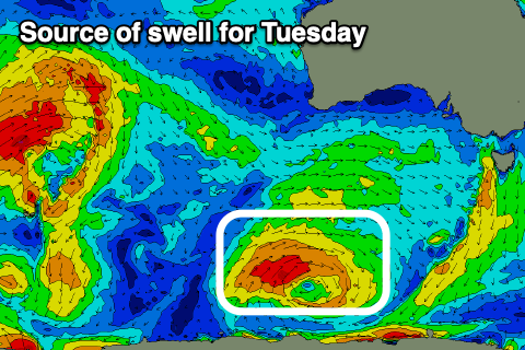
Overnight Monday and more so Tuesday, a slightly better pulse of SW swell is due, produced by a slow moving polar low on the polar shelf, south-southwest of Western Australia today and tomorrow.

This should kick the Surf Coast to 3ft+ on Tuesday with 5-6ft sets to the east and with N/NW tending NW winds that will favour locations west of Melbourne, easing a touch Wednesday with more favourable N/NW tending N/NE winds to the east.
The swell for Wednesday onwards looks to eb and pulse from the west, thanks to mid-latitude frontal systems moving in from the Indian Ocean, under the country.
There’s no major strength to them until mid-late week which should then result in some better, moderate sized energy from next weekend and beyond. More on this Monday. Have a great weekend!

